
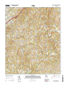
~ Chestnut Mountain GA topo map, 1:24000 scale, 7.5 X 7.5 Minute, Current, 2014
Chestnut Mountain, Georgia, USGS topographic map dated 2014.
Includes geographic coordinates (latitude and longitude). This topographic map is suitable for hiking, camping, and exploring, or framing it as a wall map.
Printed on-demand using high resolution imagery, on heavy weight and acid free paper, or alternatively on a variety of synthetic materials.
Topos available on paper, Waterproof, Poly, or Tyvek. Usually shipping rolled, unless combined with other folded maps in one order.
- Product Number: USGS-7535187
- Free digital map download (high-resolution, GeoPDF): Chestnut Mountain, Georgia (file size: 41 MB)
- Map Size: please refer to the dimensions of the GeoPDF map above
- Weight (paper map): ca. 55 grams
- Map Type: POD USGS Topographic Map
- Map Series: US Topo
- Map Verison: Current
- Cell ID: 8439
- Datum: North American Datum of 1983
- Map Projection: Transverse Mercator
- Map Cell Name: Chestnut Mountain
- Grid size: 7.5 X 7.5 Minute
- Date on map: 2014
- Map Scale: 1:24000
- Geographical region: Georgia, United States
Neighboring Maps:
All neighboring USGS topo maps are available for sale online at a variety of scales.
Spatial coverage:
Topo map Chestnut Mountain, Georgia, covers the geographical area associated the following places:
- Springfield Downs - Tanner Mill - Alandale - Colony South - Gilleland - Marlette Heights - Belmont - Chestnut Hill - Meadowood - Frazier - Bretton Woods - Klondike - Goochville - Briarwood - Bolman Estates - Evergreen Heights - Strickland Heights - Ednaville - Hillcroft Heights - Mulberry - Eaglewood - Chestnut Mountain - Pleasant Brook - Candler - Blackshear Place
- Map Area ID: AREA34.2534.125-83.875-83.75
- Northwest corner Lat/Long code: USGSNW34.25-83.875
- Northeast corner Lat/Long code: USGSNE34.25-83.75
- Southwest corner Lat/Long code: USGSSW34.125-83.875
- Southeast corner Lat/Long code: USGSSE34.125-83.75
- Northern map edge Latitude: 34.25
- Southern map edge Latitude: 34.125
- Western map edge Longitude: -83.875
- Eastern map edge Longitude: -83.75


