
~ White Mud Lake WA topo map, 1:24000 scale, 7.5 X 7.5 Minute, Current, 2014
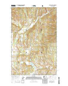
White Mud Lake, Washington, USGS topographic map dated 2014.
Includes geographic coordinates (latitude and longitude). This topographic map is suitable for hiking, camping, and exploring, or framing it as a wall map.
Printed on-demand using high resolution imagery, on heavy weight and acid free paper, or alternatively on a variety of synthetic materials.
Topos available on paper, Waterproof, Poly, or Tyvek. Usually shipping rolled, unless combined with other folded maps in one order.
- Product Number: USGS-7533779
- Free digital map download (high-resolution, GeoPDF): White Mud Lake, Washington (file size: 33 MB)
- Map Size: please refer to the dimensions of the GeoPDF map above
- Weight (paper map): ca. 55 grams
- Map Type: POD USGS Topographic Map
- Map Series: US Topo
- Map Verison: Current
- Cell ID: 48714
- Datum: North American Datum of 1983
- Map Projection: Transverse Mercator
- Map Cell Name: White Mud Lake
- Grid size: 7.5 X 7.5 Minute
- Date on map: 2014
- Map Scale: 1:24000
- Geographical region: Washington, United States
Neighboring Maps:
All neighboring USGS topo maps are available for sale online at a variety of scales.
Spatial coverage:
Topo map White Mud Lake, Washington, covers the geographical area associated the following places:
- Keogh Lake - Peery Lake - Jack Hook Gulch - White Mud Lake - Saint John's Episcopal Church - Three Forks - Graham Hill - Coonrad Hill - North Fork Mill Creek - Aladdin Pit - Crusher Canyon - Tulare Dolomite Quarry - Grevit Creek - White Rock Canyon - White Lake - Thompson Lake - Smith Airport - Colville Gun Club - White Lake Grange - Finley Gulch - De Hart Lake - Old Dominion Mine - Prouty Creek - Blue Bird Canyon - Truman Wood Creek - Prouty Corners - Jones Ridge - Joes Ridge - The Knob - Hull Creek - Middle Fork Mill Creek - Rosanna Lake Dam - White Lake School - Hawkins Quarry - Mill Creek School - Dry Gulch - Tepee Springs - Douglass Lake - South Fork Mill Creek - Old Town Mountain - Fort Colville Grange - Colville Division - Graham School
- Map Area ID: AREA48.62548.5-117.875-117.75
- Northwest corner Lat/Long code: USGSNW48.625-117.875
- Northeast corner Lat/Long code: USGSNE48.625-117.75
- Southwest corner Lat/Long code: USGSSW48.5-117.875
- Southeast corner Lat/Long code: USGSSE48.5-117.75
- Northern map edge Latitude: 48.625
- Southern map edge Latitude: 48.5
- Western map edge Longitude: -117.875
- Eastern map edge Longitude: -117.75


