
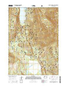
~ Lake of the Woods South OR topo map, 1:24000 scale, 7.5 X 7.5 Minute, Current, 2014
Lake of the Woods South, Oregon, USGS topographic map dated 2014.
Includes geographic coordinates (latitude and longitude). This topographic map is suitable for hiking, camping, and exploring, or framing it as a wall map.
Printed on-demand using high resolution imagery, on heavy weight and acid free paper, or alternatively on a variety of synthetic materials.
Topos available on paper, Waterproof, Poly, or Tyvek. Usually shipping rolled, unless combined with other folded maps in one order.
- Product Number: USGS-7260970
- Free digital map download (high-resolution, GeoPDF): Lake of the Woods South, Oregon (file size: 39 MB)
- Map Size: please refer to the dimensions of the GeoPDF map above
- Weight (paper map): ca. 55 grams
- Map Type: POD USGS Topographic Map
- Map Series: US Topo
- Map Verison: Current
- Cell ID: 24592
- Datum: North American Datum of 1983
- Map Projection: Transverse Mercator
- Map Cell Name: Lake of the Woods South
- Grid size: 7.5 X 7.5 Minute
- Date on map: 2014
- Map Scale: 1:24000
- Geographical region: Oregon, United States
Neighboring Maps:
All neighboring USGS topo maps are available for sale online at a variety of scales.
Spatial coverage:
Topo map Lake of the Woods South, Oregon, covers the geographical area associated the following places:
- Burton Butte - Camp Esther Applegate - Crystalline Spring - Cold Creek - Whiteface Peak - Tunnel Creek - Rainbow Springs - Sunset Recreation Site - Greylock Mountain - Crater Mountain - Low Echo Camp - Rainbow Bay - Muddy Spring - Avalanche Lake - Rainbow Creek - High Knob - Sunset Campground Boat Ramp - Ichabod Spring - Buck Lake - Lake of the Woods - Sunset Campground - Weston Lake - Mountain Lakes Trail - Surveyor Mountain Recreation Site - Lake Waban - Desolation Swamp
- Map Area ID: AREA42.37542.25-122.25-122.125
- Northwest corner Lat/Long code: USGSNW42.375-122.25
- Northeast corner Lat/Long code: USGSNE42.375-122.125
- Southwest corner Lat/Long code: USGSSW42.25-122.25
- Southeast corner Lat/Long code: USGSSE42.25-122.125
- Northern map edge Latitude: 42.375
- Southern map edge Latitude: 42.25
- Western map edge Longitude: -122.25
- Eastern map edge Longitude: -122.125


