
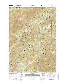
~ Whistler Point OR topo map, 1:24000 scale, 7.5 X 7.5 Minute, Current, 2014
Whistler Point, Oregon, USGS topographic map dated 2014.
Includes geographic coordinates (latitude and longitude). This topographic map is suitable for hiking, camping, and exploring, or framing it as a wall map.
Printed on-demand using high resolution imagery, on heavy weight and acid free paper, or alternatively on a variety of synthetic materials.
Topos available on paper, Waterproof, Poly, or Tyvek. Usually shipping rolled, unless combined with other folded maps in one order.
- Product Number: USGS-7255232
- Free digital map download (high-resolution, GeoPDF): Whistler Point, Oregon (file size: 42 MB)
- Map Size: please refer to the dimensions of the GeoPDF map above
- Weight (paper map): ca. 55 grams
- Map Type: POD USGS Topographic Map
- Map Series: US Topo
- Map Verison: Current
- Cell ID: 48613
- Datum: North American Datum of 1983
- Map Projection: Transverse Mercator
- Map Cell Name: Whistler Point
- Grid size: 7.5 X 7.5 Minute
- Date on map: 2014
- Map Scale: 1:24000
- Geographical region: Oregon, United States
Neighboring Maps:
All neighboring USGS topo maps are available for sale online at a variety of scales.
Spatial coverage:
Topo map Whistler Point, Oregon, covers the geographical area associated the following places:
- View Point - Hon Spring - Cougar Forest Camp - O'Neil Spring - Coyle Butte - McGinnis Creek - Marks Creek Lodge - Ochoco Mountains - Ochoco Recreation Site - Long Hollow Creek - Cornez Creek - Whistler Spring - Grant Meadows - Mahogany Spring - Thorn Creek - Koch Butte - Cox Reservoir - Whitney Creek - Claypool Spring - Garden Spring - Shamrock Creek - Garden Creek - Hamilton Butte - Stewart Spring - Hamilton Creek - Wildcat Creek - Grant Butte - Section Eight Reservoir - Willow Creek - Pothole Spring - Whistler Point - Marks Spring - Marks Lake - Douthit Creek - Rush Creek - Coyle Spring - Downs Spring - Cougar Rock - Scissors Creek - Reilly Creek - O'Neil Butte - Mount Bachelor Academy - Buck Spring - Bandit Spring Safety Rest Area - Bandit Spring - Judy Creek - Canyon Creek - Crystal Creek - Nature Creek - Buck Creek - Koch Reservoir - Fisher Creek - Ochoco Divide Research Area - O'Neil Creek - Rail Creek - Halfway Spring - Little Hay Creek - Rush Spring - Marks Lake Dam - Wickheiser Spring - Hamilton Spring - Spears Meadow - Whistler Recreation Site - Deadman Creek - Whitney Reservoir - Coyle Creek - Mercury Creek - Metal Creek
- Map Area ID: AREA44.544.375-120.5-120.375
- Northwest corner Lat/Long code: USGSNW44.5-120.5
- Northeast corner Lat/Long code: USGSNE44.5-120.375
- Southwest corner Lat/Long code: USGSSW44.375-120.5
- Southeast corner Lat/Long code: USGSSE44.375-120.375
- Northern map edge Latitude: 44.5
- Southern map edge Latitude: 44.375
- Western map edge Longitude: -120.5
- Eastern map edge Longitude: -120.375


