
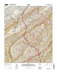
~ Birmingham South AL topo map, 1:24000 scale, 7.5 X 7.5 Minute, 2014
Birmingham South, Alabama, USGS topographic map dated 2014.
Includes geographic coordinates (latitude and longitude). This topographic map is suitable for hiking, camping, and exploring, or framing it as a wall map.
Printed on-demand using high resolution imagery, on heavy weight and acid free paper, or alternatively on a variety of synthetic materials.
Topos available on paper, Waterproof, Poly, or Tyvek. Usually shipping rolled, unless combined with other folded maps in one order.
- Product Number: USGS-7243149
- Free digital map download (high-resolution, GeoPDF): Birmingham South, Alabama (file size: 30 MB)
- Map Size: please refer to the dimensions of the GeoPDF map above
- Weight (paper map): ca. 55 grams
- Map Type: POD USGS Topographic Map
- Map Series: US Topo
- Map Verison: Current
- Cell ID: 4003
- Datum: North American Datum of 1983
- Map Projection: Transverse Mercator
- Map Cell Name: Birmingham South
- Grid size: 7.5 X 7.5 Minute
- Date on map: 2014
- Map Scale: 1:24000
- Geographical region: Alabama, United States
Neighboring Maps:
All neighboring USGS topo maps are available for sale online at a variety of scales.
Spatial coverage:
Topo map Birmingham South, Alabama, covers the geographical area associated the following places:
- Vestavia Forest - Windsor Highlands - Lakeview Estates - Indian Valley - Derby Downs Estates - Shady Brook Estates - Cherokee Forest - Vesclub Estates - Powderly Hills - Edgewood - Shades Cliff - Edgemont Park - Plantation Point - Hollywood - Brookview - Crossgate - Rocky Ridge Manor - Richmond Place - Beacon Hills - Mountain Brook Village - Belle Terre - Powderly - Vestavia Hills - Williamsburg - Tanglewood - Rosedale - Tangle Creek - Rocky Bridge - Millbrook Estates - Shades View Estates - Imperial Forest - Blue Ridge Estates - Gentilly Forest - West End - Countrywood Highlands - Surrey Hill - Edgemont - Vestwood Hills - Wisteria Commons - Rocky Ridge - Ivy Chase - Martinwood Estates - Vestbrook Trace - Wine Ridge - Thornhill - English Village - Biltmore Estates - Cedar Crest - South Vestavia Hills - Lakewood Hills - Germania - Hickory Ridge Estates - Sagewood - Mayfair - Highland Crest - Hickory Ridge Estates - Watkins Glen - Chestnut Ridge - Bluff Park - Abington Green - Mill Run - Crest - Coventry - Lochridge - Crest Estates - Oxmoor - Hoover - Regent Forest Estates - Green View Estates - Panorama - Huntington Park - Vesthaven Estates - Vestridge - Altadena Forest Estates - Woodmeadows - Sky Ranch - Highland Park - Ishkooda - Buena Vista Highlands - Mountain Oaks - Chimney Hills - Windover - Edgemoor Estates - Patton Chapel - Heatherwood - Lake Drive Estates - Glen Iris - Mason City - Lakeview Park - Southwood - Montclair - Ivy Glenn - Montreat - Oak Grove Estates - Spaulding - Verdue Knolls - Vestavia Hills Estates - Polo Trace - Country Club Highlands - Vestavia Lake
- Map Area ID: AREA33.533.375-86.875-86.75
- Northwest corner Lat/Long code: USGSNW33.5-86.875
- Northeast corner Lat/Long code: USGSNE33.5-86.75
- Southwest corner Lat/Long code: USGSSW33.375-86.875
- Southeast corner Lat/Long code: USGSSE33.375-86.75
- Northern map edge Latitude: 33.5
- Southern map edge Latitude: 33.375
- Western map edge Longitude: -86.875
- Eastern map edge Longitude: -86.75


