
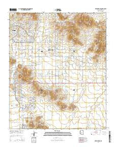
~ New River SE AZ topo map, 1:24000 scale, 7.5 X 7.5 Minute, 2014
New River SE, Arizona, USGS topographic map dated 2014.
Includes geographic coordinates (latitude and longitude). This topographic map is suitable for hiking, camping, and exploring, or framing it as a wall map.
Printed on-demand using high resolution imagery, on heavy weight and acid free paper, or alternatively on a variety of synthetic materials.
Topos available on paper, Waterproof, Poly, or Tyvek. Usually shipping rolled, unless combined with other folded maps in one order.
- Product Number: USGS-7241299
- Free digital map download (high-resolution, GeoPDF): New River SE, Arizona (file size: 25 MB)
- Map Size: please refer to the dimensions of the GeoPDF map above
- Weight (paper map): ca. 55 grams
- Map Type: POD USGS Topographic Map
- Map Series: US Topo
- Map Verison: Current
- Cell ID: 31840
- Datum: North American Datum of 1983
- Map Projection: Transverse Mercator
- Map Cell Name: New River SE
- Grid size: 7.5 X 7.5 Minute
- Date on map: 2014
- Map Scale: 1:24000
- Geographical region: Arizona, United States
Neighboring Maps:
All neighboring USGS topo maps are available for sale online at a variety of scales.
Spatial coverage:
Topo map New River SE, Arizona, covers the geographical area associated the following places:
- Daisy Mountain Fire Department Station 145 - Paradise Wash - Gunsight - Skunk Tank Wash - Gavilan Peak School - Bosco Tank - East Joy Well - Ranieri Tank Wash - Desert Hills Wash - Desert View Bible Church - Stepping Stones Academy - Apache Peak - Daisy Mountain Fire Department Station 142 - West Fork Desert Hills Wash - Crossroads Christian Fellowship - Bronco Tank - Burro Tank - East Fork Desert Lake Wash - Deer Valley Division - Rodger Creek - Ranieri Tank - Mesquite Tank - West Fork Paradise Wash - Desert Mountain School - Skunk Creek Tank - Purcell Tank - Desert Lake Wash - Anthem Golf and Country Club - Desert Hills Fellowship Church - West Fork Apache Wash - West Fork Desert Lake Wash - Black Tank - Circle Tank - Anthem Census Designated Place - Calvary Chapel of Deseret Hills - Desert Lake Tank - Bentley Well - Apache Spring - Jims Spring - Diamond Canyon Elementary School
- Map Area ID: AREA33.87533.75-112.125-112
- Northwest corner Lat/Long code: USGSNW33.875-112.125
- Northeast corner Lat/Long code: USGSNE33.875-112
- Southwest corner Lat/Long code: USGSSW33.75-112.125
- Southeast corner Lat/Long code: USGSSE33.75-112
- Northern map edge Latitude: 33.875
- Southern map edge Latitude: 33.75
- Western map edge Longitude: -112.125
- Eastern map edge Longitude: -112


