
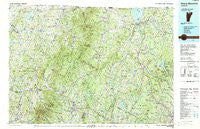
~ Mount Mansfield VT topo map, 1:100000 scale, 30 X 60 Minute, Historical, 1989, updated 1989
Mount Mansfield, Vermont, USGS topographic map dated 1989.
Includes geographic coordinates (latitude and longitude). This topographic map is suitable for hiking, camping, and exploring, or framing it as a wall map.
Printed on-demand using high resolution imagery, on heavy weight and acid free paper, or alternatively on a variety of synthetic materials.
Topos available on paper, Waterproof, Poly, or Tyvek. Usually shipping rolled, unless combined with other folded maps in one order.
- Product Number: USGS-6088473
- Free digital map download (high-resolution, GeoPDF): Mount Mansfield, Vermont (file size: 34 MB)
- Map Size: please refer to the dimensions of the GeoPDF map above
- Weight (paper map): ca. 55 grams
- Map Type: POD USGS Topographic Map
- Map Series: HTMC
- Map Verison: Historical
- Cell ID: 68003
- Scan ID: 460034
- Imprint Year: 1989
- Woodland Tint: Yes
- Aerial Photo Year: 1986
- Edit Year: 1989
- Datum: NAD27
- Map Projection: Universal Transverse Mercator
- Map published by United States Geological Survey
- Map Language: English
- Scanner Resolution: 600 dpi
- Map Cell Name: Mount Mansfield
- Grid size: 30 X 60 Minute
- Date on map: 1989
- Map Scale: 1:100000
- Geographical region: Vermont, United States
Neighboring Maps:
All neighboring USGS topo maps are available for sale online at a variety of scales.
Spatial coverage:
Topo map Mount Mansfield, Vermont, covers the geographical area associated the following places:
- Eden - Perry - Mill Village - Pottersville - Coventry - Westmore - Gebbie Corner - West Glover - Holland - South Albany - Saint Rocks - South Newport - Camp Grounds - East Greensboro - Beattys Four Corners - Montgomery - Irasburg - Berkshire - Wheelock - West Enosburg - Centerville - Bakersfield - Hardwick Center - Sheffield Square - South Franklin - Stevensville - Hectorville - Morgan - East Fletcher - Summit - Brownington Center - Underhill Center - East Johnson - East Craftsbury - Belvidere Center - Waterville - Hyde Park - East Highgate - Ramsey Corner - Fairfield - The Four Corners - Underhill - Johnson - Brownington Village - Morses Mill - Samsonville - East Sheldon - Hardwick Street - Jericho - Sunmit - Newport Center - Craftsbury - Lyndon Center - North Underhill - Stowe Fork - Newport - West Charleston - Richford - North Sheldon - North Walden - East Hardwick - Morrisville - East Enosburg - Merrill Corner - Barton - Derby Center - Sheldon - Pleasant Valley - South Franklin - West Fletcher - Montgomery Center - North Enosburg - Lake Elmore - East Fairfield - Lowell - Enosburg Falls - Albany - Cambridge - Sanderson Corner - Tice - Cloverdale - Tolman Corner - Huntsville - East Albany - Cleveland Corners - Lake Park - East Berkshire - Morristown - West Settlement - East Franklin - Glover - Jay - Lyndonville - Albany Center - South Richford - Sheldon Junction - Lyndon Center - West Berkshire - Westfield - Enosburg Center
- Map Area ID: AREA4544.5-73-72
- Northwest corner Lat/Long code: USGSNW45-73
- Northeast corner Lat/Long code: USGSNE45-72
- Southwest corner Lat/Long code: USGSSW44.5-73
- Southeast corner Lat/Long code: USGSSE44.5-72
- Northern map edge Latitude: 45
- Southern map edge Latitude: 44.5
- Western map edge Longitude: -73
- Eastern map edge Longitude: -72


