
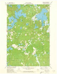
~ Spider Lake WI topo map, 1:24000 scale, 7.5 X 7.5 Minute, Historical, 1971, updated 1973
Spider Lake, Wisconsin, USGS topographic map dated 1971.
Includes geographic coordinates (latitude and longitude). This topographic map is suitable for hiking, camping, and exploring, or framing it as a wall map.
Printed on-demand using high resolution imagery, on heavy weight and acid free paper, or alternatively on a variety of synthetic materials.
Topos available on paper, Waterproof, Poly, or Tyvek. Usually shipping rolled, unless combined with other folded maps in one order.
- Product Number: USGS-6000486
- Free digital map download (high-resolution, GeoPDF): Spider Lake, Wisconsin (file size: 7 MB)
- Map Size: please refer to the dimensions of the GeoPDF map above
- Weight (paper map): ca. 55 grams
- Map Type: POD USGS Topographic Map
- Map Series: HTMC
- Map Verison: Historical
- Cell ID: 42499
- Scan ID: 800612
- Imprint Year: 1973
- Woodland Tint: Yes
- Aerial Photo Year: 1970
- Field Check Year: 1971
- Datum: NAD27
- Map Projection: Polyconic
- Map published by United States Geological Survey
- Map Language: English
- Scanner Resolution: 508 dpi
- Map Cell Name: Spider Lake
- Grid size: 7.5 X 7.5 Minute
- Date on map: 1971
- Map Scale: 1:24000
- Geographical region: Wisconsin, United States
Neighboring Maps:
All neighboring USGS topo maps are available for sale online at a variety of scales.
Spatial coverage:
Topo map Spider Lake, Wisconsin, covers the geographical area associated the following places:
- Town of Round Lake Fire Department - Station 2 - Currier Lake - Tiger Cat Dam - Sickles Lake - Whiplash Lake - Tiger Cat 2WP255 Dam - Larson Lake - Mukwonago Lake - Lake Helane - Little Ole Lake - Spider Creek - Stearns Lake - Chief River State Wildlife Management Area - Camp Four Lakes - Eagle Nest Lake - Foo Lake - Dead Lake - Clear Lake - Ole Lake - Spider Lake School (historical) - Fawn Lake - Davies Lake - One Shoe Lake - Spider Lake Fire Department Station 2 - Spider Lake Fire Department Station 1 - Spring Lake - Spider Lake - Byrd Lake - Dead Creek Spring - Dead Creek - Rush Lake - Ole Creek - Davis Lake - North Lake - Tiger Cat Flowage 47 - Trout Lake - Lake School - Wilson Creek - Town of Round Lake - Lost Land Lake - Spider Lake Townhall - Lewis Lake - Lost Land Lake Club
- Map Area ID: AREA46.12546-91.25-91.125
- Northwest corner Lat/Long code: USGSNW46.125-91.25
- Northeast corner Lat/Long code: USGSNE46.125-91.125
- Southwest corner Lat/Long code: USGSSW46-91.25
- Southeast corner Lat/Long code: USGSSE46-91.125
- Northern map edge Latitude: 46.125
- Southern map edge Latitude: 46
- Western map edge Longitude: -91.25
- Eastern map edge Longitude: -91.125


