
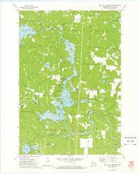
~ High Falls Reservoir WI topo map, 1:24000 scale, 7.5 X 7.5 Minute, Historical, 1972, updated 1975
High Falls Reservoir, Wisconsin, USGS topographic map dated 1972.
Includes geographic coordinates (latitude and longitude). This topographic map is suitable for hiking, camping, and exploring, or framing it as a wall map.
Printed on-demand using high resolution imagery, on heavy weight and acid free paper, or alternatively on a variety of synthetic materials.
Topos available on paper, Waterproof, Poly, or Tyvek. Usually shipping rolled, unless combined with other folded maps in one order.
- Product Number: USGS-5998398
- Free digital map download (high-resolution, GeoPDF): High Falls Reservoir, Wisconsin (file size: 7 MB)
- Map Size: please refer to the dimensions of the GeoPDF map above
- Weight (paper map): ca. 55 grams
- Map Type: POD USGS Topographic Map
- Map Series: HTMC
- Map Verison: Historical
- Cell ID: 20357
- Scan ID: 500599
- Imprint Year: 1975
- Woodland Tint: Yes
- Aerial Photo Year: 1971
- Field Check Year: 1972
- Datum: NAD27
- Map Projection: Lambert Conformal Conic
- Map published by United States Geological Survey
- Map Language: English
- Scanner Resolution: 508 dpi
- Map Cell Name: High Falls Reservoir
- Grid size: 7.5 X 7.5 Minute
- Date on map: 1972
- Map Scale: 1:24000
- Geographical region: Wisconsin, United States
Neighboring Maps:
All neighboring USGS topo maps are available for sale online at a variety of scales.
Spatial coverage:
Topo map High Falls Reservoir, Wisconsin, covers the geographical area associated the following places:
- Little Perch Lake - Huigen Lake - Thunder Lake - Island Lake - Eagle Creek - Town of Stephenson - High Falls School (historical) - Glen Lake Dam - Kiss Lake - Old Veterans Lake - Neveln Field Airport (historical) - Stephenson Municipal Fire Department Station 1and Twin Bridge Volunteer Rescue Squad - Johnson Falls Flowage 647 - Woods Lake - High Falls Reservoir 571 - Joy Lake - High Falls Dam - Kiss Lake - High Falls Reservoir - Kahles Pond - Little Eagle Creek - Caldron Falls Dam - Medicine Brook - Veterans Memorial Park - Old Veteran Lake Park - Thunder River - Caldron Falls WP186 Dam - Thunder Lake Inlet - High Falls 2WP928 Dam - Woods Lake Outlet - Thunder Lake Outlet - Squaw Lake - Caldron Falls Reservoir 496 - Angle Lake - Johnson Falls WP 153 Dam - Caldron Falls School (historical) - Johnson Falls Dam - Twin Bridge Park - Eagle Lake
- Map Area ID: AREA45.37545.25-88.25-88.125
- Northwest corner Lat/Long code: USGSNW45.375-88.25
- Northeast corner Lat/Long code: USGSNE45.375-88.125
- Southwest corner Lat/Long code: USGSSW45.25-88.25
- Southeast corner Lat/Long code: USGSSE45.25-88.125
- Northern map edge Latitude: 45.375
- Southern map edge Latitude: 45.25
- Western map edge Longitude: -88.25
- Eastern map edge Longitude: -88.125


