
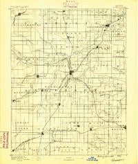
~ Garnett KS topo map, 1:125000 scale, 30 X 30 Minute, Historical, 1885
Garnett, Kansas, USGS topographic map dated 1885.
Includes geographic coordinates (latitude and longitude). This topographic map is suitable for hiking, camping, and exploring, or framing it as a wall map.
Printed on-demand using high resolution imagery, on heavy weight and acid free paper, or alternatively on a variety of synthetic materials.
Topos available on paper, Waterproof, Poly, or Tyvek. Usually shipping rolled, unless combined with other folded maps in one order.
- Product Number: USGS-5971096
- Free digital map download (high-resolution, GeoPDF): Garnett, Kansas (file size: 5 MB)
- Map Size: please refer to the dimensions of the GeoPDF map above
- Weight (paper map): ca. 55 grams
- Map Type: POD USGS Topographic Map
- Map Series: HTMC
- Map Verison: Historical
- Cell ID: 65547
- Scan ID: 122520
- Survey Year: 1885
- Datum: Unstated
- Map Projection: Unstated
- Map published by United States Geological Survey
- Map Language: English
- Scanner Resolution: 600 dpi
- Map Cell Name: Garnett
- Grid size: 30 X 30 Minute
- Date on map: 1885
- Map Scale: 1:125000
- Geographical region: Kansas, United States
Neighboring Maps:
All neighboring USGS topo maps are available for sale online at a variety of scales.
Spatial coverage:
Topo map Garnett, Kansas, covers the geographical area associated the following places:
- Central - Westphalia - Scipio - Centerville - Glenlock - Colony - Mont Ida - Garnett - Geneva - Harris - Silkville - Princeton - Williamsburg - Selma - Blue Mound - Greeley - Welda - Princeton Mobile Home Park - Lane - Bush City - Kincaid - Mildred - Lone Elm - Richmond
- Map Area ID: AREA38.538-95.5-95
- Northwest corner Lat/Long code: USGSNW38.5-95.5
- Northeast corner Lat/Long code: USGSNE38.5-95
- Southwest corner Lat/Long code: USGSSW38-95.5
- Southeast corner Lat/Long code: USGSSE38-95
- Northern map edge Latitude: 38.5
- Southern map edge Latitude: 38
- Western map edge Longitude: -95.5
- Eastern map edge Longitude: -95


