
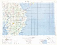
~ Salisbury MD topo map, 1:250000 scale, 1 X 2 Degree, Historical, 1957, updated 1957
Salisbury, Maryland, USGS topographic map dated 1957.
Includes geographic coordinates (latitude and longitude). This topographic map is suitable for hiking, camping, and exploring, or framing it as a wall map.
Printed on-demand using high resolution imagery, on heavy weight and acid free paper, or alternatively on a variety of synthetic materials.
Topos available on paper, Waterproof, Poly, or Tyvek. Usually shipping rolled, unless combined with other folded maps in one order.
- Product Number: USGS-5930579
- Free digital map download (high-resolution, GeoPDF): Salisbury, Maryland (file size: 21 MB)
- Map Size: please refer to the dimensions of the GeoPDF map above
- Weight (paper map): ca. 55 grams
- Map Type: POD USGS Topographic Map
- Map Series: HTMC
- Map Verison: Historical
- Cell ID: 74990
- Scan ID: 461480
- Imprint Year: 1957
- Woodland Tint: Yes
- Datum: Unstated
- Map Projection: Transverse Mercator
- Map published by United States Army
- Map Language: English
- Scanner Resolution: 600 dpi
- Map Cell Name: Salisbury
- Grid size: 1 X 2 Degree
- Date on map: 1957
- Map Scale: 1:250000
- Geographical region: Maryland, United States
Neighboring Maps:
All neighboring USGS topo maps are available for sale online at a variety of scales.
Spatial coverage:
Topo map Salisbury, Maryland, covers the geographical area associated the following places:
- Johnson Development - Eastman Heights - Steele Acres - Simms Wharf - Bramblewood - Jersey Road Estates - Heritage Village - Scarboro Landing - Brookview - Messick Development - Tussock Pond - John Walstons Mobile Home Park - Hudson Heights - Shavox - Foxchase - Wetipquin - Marion - Kathleens Delight - Carsylian Acres - Shiloh Church - Bayberry Dunes - Leisure Point Mobile Home Park - Townsends Cross Roads - Southside Trailer Park - Ridgely - Gum Swamp - Bayview (historical) - Pusey Development - Cripple Creek - Beaver Run Manor - Breezewood - Westside Mobile Home Park - Savannah Place - Vernon - Colony West - Sandy Fork - Fenwick - Patty Cannon Estates - Banks Development - Holly Lake Mobile Home Park - Tuckahoe Springs - Double Hills Estates - Thompsontown - Reliance - Broad Creek - Forest Park Mobile Home Park - Linda Manor - Peppers Landing - Lincoln - Holly Ridge - Dutch Acres - Hillsboro Estates - Log Cabin Mobile Home Park - Dogwood Village - Hollyville - Pots Nets North Mobile Home Park - Annemessix Towne (historical) - Marumsco - Greenland - Sea Colony - Blackwater - Bay Shore Mobile Home Park - Pintail Isle - Flea Hill - Banks Harbor Estates - Unionville Heights - Frenchtown - Edgewater Acres - Doe Run - Paris Woods - Lowes Crossroads - Ray Park Heights - Blanchard - Victor (historical) - Pusey Crossroads - Patterson Place Mobile Home Park - Montego Bay - Kilbirnie Estates - Mason Landing - Midway Estates - Mount Pleasant - Ferry Landing - Jacksons Ridge - Patricks Landing - North Milford (historical) - Ross - Henlopen Keys - Saint Martins by the Bay - Wellington - Bainbridge - Argos Choice - Bivalve - Rewastico - Fairmount - Public Landing - Windham Manor - Rush Acres - Springfield Crossroads - Oak Hill Estates - Spring Brook Forest
- Map Area ID: AREA3938-76-74
- Northwest corner Lat/Long code: USGSNW39-76
- Northeast corner Lat/Long code: USGSNE39-74
- Southwest corner Lat/Long code: USGSSW38-76
- Southeast corner Lat/Long code: USGSSE38-74
- Northern map edge Latitude: 39
- Southern map edge Latitude: 38
- Western map edge Longitude: -76
- Eastern map edge Longitude: -74


