
~ Cumberland MD topo map, 1:250000 scale, 1 X 2 Degree, Historical, 1961
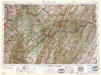
Cumberland, Maryland, USGS topographic map dated 1961.
Includes geographic coordinates (latitude and longitude). This topographic map is suitable for hiking, camping, and exploring, or framing it as a wall map.
Printed on-demand using high resolution imagery, on heavy weight and acid free paper, or alternatively on a variety of synthetic materials.
Topos available on paper, Waterproof, Poly, or Tyvek. Usually shipping rolled, unless combined with other folded maps in one order.
- Product Number: USGS-5930311
- Free digital map download (high-resolution, GeoPDF): Cumberland, Maryland (file size: 31 MB)
- Map Size: please refer to the dimensions of the GeoPDF map above
- Weight (paper map): ca. 55 grams
- Map Type: POD USGS Topographic Map
- Map Series: HTMC
- Map Verison: Historical
- Cell ID: 68734
- Scan ID: 461424
- Woodland Tint: Yes
- Field Check Year: 1956
- Datum: Unstated
- Map Projection: Transverse Mercator
- Map published by United States Army Corps of Engineers
- Map published by United States Army
- Map Language: English
- Scanner Resolution: 600 dpi
- Map Cell Name: Cumberland
- Grid size: 1 X 2 Degree
- Date on map: 1961
- Map Scale: 1:250000
- Geographical region: Maryland, United States
Neighboring Maps:
All neighboring USGS topo maps are available for sale online at a variety of scales.
Spatial coverage:
Topo map Cumberland, Maryland, covers the geographical area associated the following places:
- Valley (historical) - The Mileground - Wheatfield - Hardesty - Brandonville - Breezewood - The Knolls - Goose Nest - Victoria - Meadowville - Masontown - Allison Heights - Dillons Run (historical) - Irishtown - Sinclair - Downey - Westerman (historical) - Stanley - Bayard - Brentwood Terrace - McMellin (historical) - Southview - Deer Park - Southwood Hills - Hilderbrand - Cheat Neck - Old Frame - Berryville - Hopewell - Deffenbaugh - Wiles Hill - Kingwood - Ursina - High Point - Boynton - Woodchuck Heights - Merrittstown - Hazelhurst - Points - Dogwood Flats - Amcelle - Mann - McClellandtown - Zar (historical) - William - Hazelton - Rig - Fairbank - Carpendale - Grimes - Spring Meadows Trailer Park - Johnsontown - Mahoning - Saratoga - Pinto - Sector - McKinley Hill - Fairmor - Fairway Meadows - Doman (historical) - Whitacre - Shafer - Jefferis - Sabraton - Rogers Mill - Millesons Mill - Deer Lake - Spring Valley - Oliver - High View Manor - Fort Ashby - Brookneil - Chestnut Ridge - Cranesville - Vannoys Mill - Lesmalinston - Rolling Fields - McQuire - Moffitt Sterling - Wadesville - Jessop - Rest - Snider - Highhouse - Spohrs Crossroads - Woodrow - Cedar Hill - Headlee Heights - Allegany Grove - Kennells Mill - Cumberland Heights - Davidson - Slanesville - North Branch - Day - Mar Village - Sycamore - Kalamazoo - Mountain View - Hays - Buffington
- Map Area ID: AREA4039-80-78
- Northwest corner Lat/Long code: USGSNW40-80
- Northeast corner Lat/Long code: USGSNE40-78
- Southwest corner Lat/Long code: USGSSW39-80
- Southeast corner Lat/Long code: USGSSE39-78
- Northern map edge Latitude: 40
- Southern map edge Latitude: 39
- Western map edge Longitude: -80
- Eastern map edge Longitude: -78


