
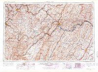
~ Cumberland MD topo map, 1:250000 scale, 1 X 2 Degree, Historical, 1956, updated 1966
Cumberland, Maryland, USGS topographic map dated 1956.
Includes geographic coordinates (latitude and longitude). This topographic map is suitable for hiking, camping, and exploring, or framing it as a wall map.
Printed on-demand using high resolution imagery, on heavy weight and acid free paper, or alternatively on a variety of synthetic materials.
Topos available on paper, Waterproof, Poly, or Tyvek. Usually shipping rolled, unless combined with other folded maps in one order.
- Product Number: USGS-5930309
- Free digital map download (high-resolution, GeoPDF): Cumberland, Maryland (file size: 25 MB)
- Map Size: please refer to the dimensions of the GeoPDF map above
- Weight (paper map): ca. 55 grams
- Map Type: POD USGS Topographic Map
- Map Series: HTMC
- Map Verison: Historical
- Cell ID: 68734
- Scan ID: 461423
- Imprint Year: 1966
- Visual Version Number: 2
- Field Check Year: 1956
- Datum: Unstated
- Map Projection: Transverse Mercator
- Map published by United States Army Corps of Engineers
- Map published by United States Army
- Map Language: English
- Scanner Resolution: 600 dpi
- Map Cell Name: Cumberland
- Grid size: 1 X 2 Degree
- Date on map: 1956
- Map Scale: 1:250000
- Geographical region: Maryland, United States
Neighboring Maps:
All neighboring USGS topo maps are available for sale online at a variety of scales.
Spatial coverage:
Topo map Cumberland, Maryland, covers the geographical area associated the following places:
- Inglesmith - Glengary - Mount Savage - Warrens Mill - Mount Hope - Halleck - Davidson - Detmold - Needmore - Phoenix (historical) - Westover - Fairmont - Barnum - East Riverside - Moore - Rockville - Tower Hill Number Two - Antioch - Palmer - Leckrone - William - Nilan - Franklin - Slabtown - Junction - Hoyes Run - McKinley Hill - Evansville - High View Manor - Location - Ringgold - Woodburn - Sigsbee - Cascade - Jones Springs - McLean (historical) - Elk Park - Boynton - Pierce - Pisgah - East Uniontown - Dority - Wilde Acres - Valley Furnace - Sutherland (historical) - Amblersburg - Wills Creek - Fairway Estates - Chapel Estates - Frenchburg - Continental Number 2 - Wrights (historical) - Arensburg - Zepp - Millen - Gannon - Cheat Neck - Sylvan Lane - Centerville - Evans - Cabbage Flats - Newtown - Hovatter - Mineral Spring - Mount Vernon - New Geneva - Skipnish (historical) - Meyersdale - Sunshine - Brownfield - Windom (historical) - Headsville - Brookneil - Streby - Mount Storm - Emoryville - Lincoln Estates - Stonybreak - Bowest - Sunnyside - Doman (historical) - Patience - Dogtown - South Hills - Charlesville - Chestnut Ridge - Fairbank - Ackerman (historical) - Briggs - Richard - Rawlings Heights - Mountain Falls Park - Little Summit - Hoyes - Bitner - White Post - Gapsville - Berryville - Hampshire - Lashley
- Map Area ID: AREA4039-80-78
- Northwest corner Lat/Long code: USGSNW40-80
- Northeast corner Lat/Long code: USGSNE40-78
- Southwest corner Lat/Long code: USGSSW39-80
- Southeast corner Lat/Long code: USGSSE39-78
- Northern map edge Latitude: 40
- Southern map edge Latitude: 39
- Western map edge Longitude: -80
- Eastern map edge Longitude: -78


