
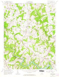
~ Clarksville MD topo map, 1:24000 scale, 7.5 X 7.5 Minute, Historical, 1957, updated 1966
Clarksville, Maryland, USGS topographic map dated 1957.
Includes geographic coordinates (latitude and longitude). This topographic map is suitable for hiking, camping, and exploring, or framing it as a wall map.
Printed on-demand using high resolution imagery, on heavy weight and acid free paper, or alternatively on a variety of synthetic materials.
Topos available on paper, Waterproof, Poly, or Tyvek. Usually shipping rolled, unless combined with other folded maps in one order.
- Product Number: USGS-5930289
- Free digital map download (high-resolution, GeoPDF): Clarksville, Maryland (file size: 11 MB)
- Map Size: please refer to the dimensions of the GeoPDF map above
- Weight (paper map): ca. 55 grams
- Map Type: POD USGS Topographic Map
- Map Series: HTMC
- Map Verison: Historical
- Cell ID: 8953
- Scan ID: 461387
- Imprint Year: 1966
- Woodland Tint: Yes
- Aerial Photo Year: 1955
- Field Check Year: 1957
- Survey Year: 1943
- Datum: NAD27
- Map Projection: Polyconic
- Map published by United States Geological Survey
- Map published by United States Army Corps of Engineers
- Map published by United States Army
- Map Language: English
- Scanner Resolution: 600 dpi
- Map Cell Name: Clarksville
- Grid size: 7.5 X 7.5 Minute
- Date on map: 1957
- Map Scale: 1:24000
- Geographical region: Maryland, United States
Neighboring Maps:
All neighboring USGS topo maps are available for sale online at a variety of scales.
Spatial coverage:
Topo map Clarksville, Maryland, covers the geographical area associated the following places:
- Ednor - Jocelyn Acres - Simpsonville - Riverside - Allnut Farms Estates - Ashton Pond - Raintree Estates - Faulkner Ridge - Linden Chapel Hills - Cedar Woods - Hillcrest Heights - Scott Acres - Braeburn - Chris Mar Estates - Greene Fields - Twelve Hills - Elioak - Farside - Twin Oaks - Clarys Forest - Kings Manor - Scaggsville - Tower Acres - Brighton Pines - Mauck Farm Estates - Hallmark - Broadwater Estates - Swann Hills - La Isla - Holiday Hills - The Chase - Fulton - Chelsea Estates - Clarksville - Briaridge - Pembroke Knolls - Waterford - Highland Acres - Highland - Hawthorn North - Hammond Village - Hawthorn - Harpers Choice - Rocky Gorge Meadows - Clarksville Meadows - Longfellow - Dogwood - Ednor View - Dunfretten Estates - Lime Kiln Valley - Mill Grove Gardens - Beaufort Park - Saybrook - Chriswood Manor - White Oak Estates - Pine Valley - Fox Pause - Hammond Park - Oak Hill Estates - Kindler Estates - Coon Manor - Greenwood Farms - Cliftonbrook - Dayton Meadows - Brighton Farm Estates - Williams Contrivance Estates - Green Hill Manor - Foxhall Villas - Clarksville Ridge - Linden Chapel Woods - Beech Creek - Cabin Hill - Hopkins Mead - Point of Homewood - Heritage Heights - Wood Ridge - Flamewood - Gaither Farm Estates - Forest Hills - Cedar Knoll Farms - Hemlock Hill - Graeloch Woods - Dayton - Patuxent Hills - Clemens Crossing - Hall Shop Estates - Swansfield - Cedar Acres - Highland Lake - Ednor Farms - Hammond Hills - Leishear Village - Ashmead - Riverside Estates - Hobbits Glen - Murray Hill - Chapel Woods - Simpson Woods - Mooresfield - Holly House
- Map Area ID: AREA39.2539.125-77-76.875
- Northwest corner Lat/Long code: USGSNW39.25-77
- Northeast corner Lat/Long code: USGSNE39.25-76.875
- Southwest corner Lat/Long code: USGSSW39.125-77
- Southeast corner Lat/Long code: USGSSE39.125-76.875
- Northern map edge Latitude: 39.25
- Southern map edge Latitude: 39.125
- Western map edge Longitude: -77
- Eastern map edge Longitude: -76.875


