
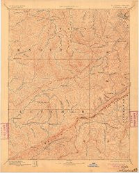
~ Whitesburg KY topo map, 1:125000 scale, 30 X 30 Minute, Historical, 1892, updated 1904
Whitesburg, Kentucky, USGS topographic map dated 1892.
Includes geographic coordinates (latitude and longitude). This topographic map is suitable for hiking, camping, and exploring, or framing it as a wall map.
Printed on-demand using high resolution imagery, on heavy weight and acid free paper, or alternatively on a variety of synthetic materials.
Topos available on paper, Waterproof, Poly, or Tyvek. Usually shipping rolled, unless combined with other folded maps in one order.
- Product Number: USGS-5930175
- Free digital map download (high-resolution, GeoPDF): Whitesburg, Kentucky (file size: 7 MB)
- Map Size: please refer to the dimensions of the GeoPDF map above
- Weight (paper map): ca. 55 grams
- Map Type: POD USGS Topographic Map
- Map Series: HTMC
- Map Verison: Historical
- Cell ID: 396093
- Scan ID: 804332
- Imprint Year: 1904
- Survey Year: 1885
- Datum: Unstated
- Map Projection: Unstated
- Map published by United States Geological Survey
- Map Language: English
- Scanner Resolution: 508 dpi
- Map Cell Name: Whitesburg
- Grid size: 30 X 30 Minute
- Date on map: 1892
- Map Scale: 1:125000
- Geographical region: Kentucky, United States
Neighboring Maps:
All neighboring USGS topo maps are available for sale online at a variety of scales.
Spatial coverage:
Topo map Whitesburg, Kentucky, covers the geographical area associated the following places:
- Cody (historical) - Sylvester (historical) - Mayking - Soft Shell - Teaberry - Mayo Village - North Fork - Odgen Gap - Betty - Deane - Isom - Hugh - Linefork - Wheelwright Junction - Grethel - Kite - Estill - Lower Long Fork (historical) - McDowell - Dongola - Baden - Thornton - Robinson Creek - Spider - Raven - Penny - Bellcraft - West Whitesburg (historical) - Hindman - Smoot Creek (historical) - Esco - Big Card (historical) - Thornton Gap - Pikeville - Breeding Creek (historical) - Big Laurel - Long Fork (historical) - Elimer - Osborne Fork (historical) - Wheelwright - Flat Gap - Right Fork of Long Fork (historical) - Gaskill - Dewey - Craftsville (historical) - Fleming - Potters Fork - Crafts Colly (historical) - Dema - Sackett - Tolliver Town - Wayland - Partridge - Amelia - Hurricane - Defeated Creek - Smithsboro (historical) - Irishmans (historical) - Galveston - Dunham - East Jenkins - West Garrett - Camp Branch (historical) - Yeager - Hueysville (historical) - Bottom Fork (historical) - Lionilli - Garner - Whitesburg - May - Littcarr - Indian Bottom (historical) - Speight - Martinsville (historical) - Hylton - Upper Cumberland (historical) - Pauley - Haddonfield - Seco - Day - Almira - Porter (historical) - Lower Chloe (historical) - Jacks Creek - Marlowe - Price - Kona - Puncheon - McRoberts - Minnie - Welco Station - Turkey Pen (historical) - Halo - Douglas - Fleming-Neon - Handshoe - Upper Little Creek (historical) - Frogtown (historical) - Dorton - Mousie
- Map Area ID: AREA37.537-83-82.5
- Northwest corner Lat/Long code: USGSNW37.5-83
- Northeast corner Lat/Long code: USGSNE37.5-82.5
- Southwest corner Lat/Long code: USGSSW37-83
- Southeast corner Lat/Long code: USGSSE37-82.5
- Northern map edge Latitude: 37.5
- Southern map edge Latitude: 37
- Western map edge Longitude: -83
- Eastern map edge Longitude: -82.5


