
~ Island Of Ponape South Half FM topo map, 1:25000 scale, 7.5 X 7.5 Minute, Historical, 1983, updated 1983
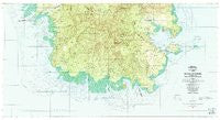
Island Of Ponape South Half , Federated States of Micronesia, USGS topographic map dated 1983.
Includes geographic coordinates (latitude and longitude). This topographic map is suitable for hiking, camping, and exploring, or framing it as a wall map.
Printed on-demand using high resolution imagery, on heavy weight and acid free paper, or alternatively on a variety of synthetic materials.
Topos available on paper, Waterproof, Poly, or Tyvek. Usually shipping rolled, unless combined with other folded maps in one order.
- Product Number: USGS-5930061
- Free digital map download (high-resolution, GeoPDF): Island Of Ponape South Half , Federated States of Micronesia (file size: 33 MB)
- Map Size: please refer to the dimensions of the GeoPDF map above
- Weight (paper map): ca. 55 grams
- Map Type: POD USGS Topographic Map
- Map Series: HTMC
- Map Verison: Historical
- Cell ID: 76710
- Scan ID: 462390
- Imprint Year: 1983
- Woodland Tint: Yes
- Aerial Photo Year: 1975
- Edit Year: 1983
- Field Check Year: 1980
- Datum: Guam 1963
- Map Projection: Universal Transverse Mercator
- Map published by United States Geological Survey
- Map Language: English
- Scanner Resolution: 600 dpi
- Map Cell Name: Island of Pohnpei (South Half)
- Grid size: 7.5 X 7.5 Minute
- Date on map: 1983
- Map Scale: 1:25000
- Geographical region: Federated States of Micronesia, United States
Neighboring Maps:
All neighboring USGS topo maps are available for sale online at a variety of scales.
Spatial coverage:
Topo map Island Of Ponape South Half , Federated States of Micronesia, covers the geographical area associated the following places:
- Ninlehur - Tamworohi - Nih Pwongin - Rekihpas - Noahle - Luak - Deleurlap - Nan Lukop - Nin Loang - Pohn Pw - Pohnlangas - Pahn Kipar - Pohn Keimw - Pohn Allap - Sakartik - Kehki - Pohn Imwinsapw - Mwoalok - Pohntakaitohr - Nih Kawad - Peiai - Dien Pei - Nankepiniak - Pidek Keren - Madol Peidak - Soupihr - Loangen Semwei - Pohndau - Sakarakapw - Ahlek - Sekeren Pei - Lehiak - Nankoaroak - Arapwa - Kamweng - Mwasangapw - Elenieng - Pohn Saleng - Mahnd - Adohro - Nan Pailong - Nan Keptik - Pohnseiuh - Tahio - Pohn Semwet - Mwelin - Nan Paremwed - Lahkir - Diadi - Pahn Peikapw - Pein Semwei - Pahn Sekeren - Pohn Iak - Dolesewi Powe - Nan Lukop - Pahn Diadi - Salong - Nanesenlak - Nihsou - Pohnered - Leurahn - Pohn Paip - Lapwusi - Rohi - Pwudoi - Pohniak - Luhkeileng - Pohnmed - Pakara - Edinsei - Imwin Diadi - Nanwei - Depe - Parau - Arohn - Pohnauleng - Pohn Uhs - Nanriohk - Pahnaiau - Nihmesehl - Madol Peidi - Ni Aul - Nihwel - Paieke - Nanwei - Nanseping - Seiten - Kepin Rohi - Sekeren Lapahu - Nanpahlap - Pohn Dolekirou - Sekeren Kahle - Masatipw - Pohnmall - Pahnios - Pohn Pwet - Loangen Rohi - Malewehlap - Pohn Kali - Pahn Tehlap
- Map Area ID: AREA6.90833336.75158.0833333158.3833333
- Northwest corner Lat/Long code: USGSNW6.9083333158.0833333
- Northeast corner Lat/Long code: USGSNE6.9083333158.3833333
- Southwest corner Lat/Long code: USGSSW6.75158.0833333
- Southeast corner Lat/Long code: USGSSE6.75158.3833333
- Northern map edge Latitude: 6.9083333
- Southern map edge Latitude: 6.75
- Western map edge Longitude: 158.0833333
- Eastern map edge Longitude: 158.3833333


