
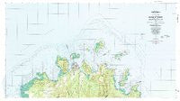
~ Island Of Ponape North Half FM topo map, 1:25000 scale, 7.5 X 7.5 Minute, Historical, 1983, updated 1983
Island Of Ponape North Half , Federated States of Micronesia, USGS topographic map dated 1983.
Includes geographic coordinates (latitude and longitude). This topographic map is suitable for hiking, camping, and exploring, or framing it as a wall map.
Printed on-demand using high resolution imagery, on heavy weight and acid free paper, or alternatively on a variety of synthetic materials.
Topos available on paper, Waterproof, Poly, or Tyvek. Usually shipping rolled, unless combined with other folded maps in one order.
- Product Number: USGS-5930059
- Free digital map download (high-resolution, GeoPDF): Island Of Ponape North Half , Federated States of Micronesia (file size: 36 MB)
- Map Size: please refer to the dimensions of the GeoPDF map above
- Weight (paper map): ca. 55 grams
- Map Type: POD USGS Topographic Map
- Map Series: HTMC
- Map Verison: Historical
- Cell ID: 76709
- Scan ID: 462391
- Imprint Year: 1983
- Woodland Tint: Yes
- Aerial Photo Year: 1975
- Field Check Year: 1980
- Datum: Guam 1963
- Map Projection: Universal Transverse Mercator
- Map published by United States Geological Survey
- Map Language: English
- Scanner Resolution: 600 dpi
- Map Cell Name: Island of Pohnpei (North Half)
- Grid size: 7.5 X 7.5 Minute
- Date on map: 1983
- Map Scale: 1:25000
- Geographical region: Federated States of Micronesia, United States
Neighboring Maps:
All neighboring USGS topo maps are available for sale online at a variety of scales.
Spatial coverage:
Topo map Island Of Ponape North Half , Federated States of Micronesia, covers the geographical area associated the following places:
- Sokehs Pah - Luhke - Nanloahr - Saladak - Pohndau - Kepindau - Roie - Likin Peinko - Pohn Maka - Peteil - Pahn Kalang - Mwoakot - Pahlap - Peinsong - Pahnaul - Alamoar - Malewe - Nan Lewitik - Nipaip - Maramosok - Tomwara - Seidihne - Nanseinpwel - Nansolohi - Nanpahie - Kepin Keileng - Pelik - Danipei - Nin Tukenwar - Metipw En Uh - Pohnrakied - Ipwek - Kurumw - Peidie - Nantipw - Lietpas - Nan Wapang - Sakaralap - Meiuhpw - Nihmoak - Keimwin Kiti - Likkie - Mwalok - Woloke - Marap - Pahn Parahdak - Sopwlong - Nipaip - Souhna - Nan Kepikep - Sakariso - Aderew - Pahntorong - Ipat - Paies - Palikir - Pohn Mwasowel - Nankapairong - Nanmeir - Wap - Ninlus - Soledi - Naneir - Ipwal - Iohl - Kamwele - Nanitipw - Nan Loangitik - Sapwtakai - Pohnsou - Nansepsep - Ninseitamw - Lipwour - Metipw En Awak - Kepinleh - Poatoik - Mesenieng - Nanpohnsapw - Peilong - Sounting - Nin Soksok - Peilik - Kolonia - Pohn Koi - Muntakai - Pahnasang - Nuehs - Pahnisou - Awak Pah - Pohn Keimw - Ahseia - Nanpei - Dekehn Iap - Kitialap - Kepin Awak - Peisou - Pahn Lepindong - Dienrar - Nanpeinering - Loangen Alemwet
- Map Area ID: AREA7.0756.9083333158.0833333158.3833333
- Northwest corner Lat/Long code: USGSNW7.075158.0833333
- Northeast corner Lat/Long code: USGSNE7.075158.3833333
- Southwest corner Lat/Long code: USGSSW6.9083333158.0833333
- Southeast corner Lat/Long code: USGSSE6.9083333158.3833333
- Northern map edge Latitude: 7.075
- Southern map edge Latitude: 6.9083333
- Western map edge Longitude: 158.0833333
- Eastern map edge Longitude: 158.3833333


