
~ Putnam RI topo map, 1:125000 scale, 30 X 30 Minute, Historical, 1943, updated 1944
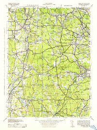
Putnam, Rhode Island, USGS topographic map dated 1943.
Includes geographic coordinates (latitude and longitude). This topographic map is suitable for hiking, camping, and exploring, or framing it as a wall map.
Printed on-demand using high resolution imagery, on heavy weight and acid free paper, or alternatively on a variety of synthetic materials.
Topos available on paper, Waterproof, Poly, or Tyvek. Usually shipping rolled, unless combined with other folded maps in one order.
- Product Number: USGS-5930017
- Free digital map download (high-resolution, GeoPDF): Putnam, Rhode Island (file size: 8 MB)
- Map Size: please refer to the dimensions of the GeoPDF map above
- Weight (paper map): ca. 55 grams
- Map Type: POD USGS Topographic Map
- Map Series: HTMC
- Map Verison: Historical
- Cell ID: 66406
- Scan ID: 461285
- Imprint Year: 1944
- Woodland Tint: Yes
- Datum: NAD27
- Map Projection: Polyconic
- Map published by United States Army Corps of Engineers
- Map published by United States Army
- Map published by United States Department of War
- Map Language: English
- Scanner Resolution: 600 dpi
- Map Cell Name: Putnam
- Grid size: 30 X 30 Minute
- Date on map: 1943
- Map Scale: 1:125000
- Geographical region: Rhode Island, United States
Neighboring Maps:
All neighboring USGS topo maps are available for sale online at a variety of scales.
Spatial coverage:
Topo map Putnam, Rhode Island, covers the geographical area associated the following places:
- Places Corner - West Greenwich - Glen Rock - River Point - Quebec - Hope - Spragueville - Potterville - Thompson - Slocum - Cranstons Corner (historical) - Glasgo - Liberty - Central Village - Mechanicsville - Forestdale - South Scituate (historical) - Primrose - Pachaug - Massomuck (historical) - Dorrville (historical) - East Putnam - Hopkins Mills - Wauregan Station - Richmond (historical) - Fairbanks Corner - Gortons Corner - Beachdale - Rockville - Plainfield - West Glocester - Cooks Corner - Putnam Heights - East Brooklyn - Danielson - Oak Valley - Moosup Valley - South Woodstock - Rockland (historical) - Voluntown - Clayville - Laurel Hill - Nooseneck - Hope Valley - Fiskeville - Millville - Wyoming - Barberville - Birch Hill (historical) - North Scituate - Brooklyn - Bishop Heights - Clarkville - Ashland (historical) - Tripps Corner - Ponaganset (historical) - Pomfret Landing - Killingly Center - Arcadia - Whipple - Sterling - Spencers Corner - Bridgeton - Woods Corner - Acquidaneck (historical) - Horn Heap - Washington - Canterbury - Harrisville - Vernon - Fountain Spring - Foster - Harrisdale - Oakland - Simmonsville - Elmdale (historical) - Tarkiln - West Greenville - Elliotville (historical) - Black Plain - Moosup - Shippee Corner - Packer - Grosvenor Dale - Anthony - Gazzaville - Waldron Corners - Vaughn Hollow - West Warwick - Centerville - Usquepaug - North Foster - Mohegan - Moscow - Pine Hill - Jewett City - Globe - Lewis City - Preston City - Harmony
- Map Area ID: AREA4241.5-72-71.5
- Northwest corner Lat/Long code: USGSNW42-72
- Northeast corner Lat/Long code: USGSNE42-71.5
- Southwest corner Lat/Long code: USGSSW41.5-72
- Southeast corner Lat/Long code: USGSSE41.5-71.5
- Northern map edge Latitude: 42
- Southern map edge Latitude: 41.5
- Western map edge Longitude: -72
- Eastern map edge Longitude: -71.5


