
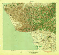
~ Rincon PR topo map, 1:30000 scale, 7.5 X 7.5 Minute, Historical, 1941
Rincon, Puerto Rico, USGS topographic map dated 1941.
Includes geographic coordinates (latitude and longitude). This topographic map is suitable for hiking, camping, and exploring, or framing it as a wall map.
Printed on-demand using high resolution imagery, on heavy weight and acid free paper, or alternatively on a variety of synthetic materials.
Topos available on paper, Waterproof, Poly, or Tyvek. Usually shipping rolled, unless combined with other folded maps in one order.
- Product Number: USGS-5689630
- Free digital map download (high-resolution, GeoPDF): Rincon, Puerto Rico (file size: 13 MB)
- Map Size: please refer to the dimensions of the GeoPDF map above
- Weight (paper map): ca. 55 grams
- Map Type: POD USGS Topographic Map
- Map Series: HTMC
- Map Verison: Historical
- Cell ID: 37942
- Scan ID: 362555
- Woodland Tint: Yes
- Survey Year: 1939
- Datum: Puerto Rico
- Map Projection: Polyconic
- Map published by United States Geological Survey
- Keywords: Overedge with No Adjacent Map
- Map Language: English
- Scanner Resolution: 600 dpi
- Map Cell Name: Rincon
- Grid size: 7.5 X 7.5 Minute
- Date on map: 1941
- Map Scale: 1:30000
- Geographical region: Puerto Rico, United States
Neighboring Maps:
All neighboring USGS topo maps are available for sale online at a variety of scales.
Spatial coverage:
Topo map Rincon, Puerto Rico, covers the geographical area associated the following places:
- La Mina - Luyando Comunidad - Rincón Zona Urbana - Las Marías Comunidad - Las Corozas - Stella Comunidad - Centro Puntas - Sagrado Corazon - Colonia Dolores - Luyando - Añasco Zona Urbana - Parque Atletico Francisco Pagan - Centro Calvache - Las Marias - Tres Hermanos - Imperial Court - Hacienda Eugenia - Pico Alalaya - Daguey - Residencial Francisco Figueroa - Barrio Guayabo - Matias - Los Maestros - La Tosca - Stella - Villas de Anasco - La Playa Comunidad - Córcega - La Puente - San Antonio - Rincón - Jardines de Anasco - La Playa - Playa Grande - Añasco
- Map Area ID: AREA18.37518.25-67.2708333-67.125
- Northwest corner Lat/Long code: USGSNW18.375-67.2708333
- Northeast corner Lat/Long code: USGSNE18.375-67.125
- Southwest corner Lat/Long code: USGSSW18.25-67.2708333
- Southeast corner Lat/Long code: USGSSE18.25-67.125
- Northern map edge Latitude: 18.375
- Southern map edge Latitude: 18.25
- Western map edge Longitude: -67.2708333
- Eastern map edge Longitude: -67.125


