
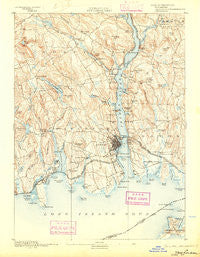
~ New London CT topo map, 1:62500 scale, 15 X 15 Minute, Historical, 1893, updated 1903
New London, Connecticut, USGS topographic map dated 1893.
Includes geographic coordinates (latitude and longitude). This topographic map is suitable for hiking, camping, and exploring, or framing it as a wall map.
Printed on-demand using high resolution imagery, on heavy weight and acid free paper, or alternatively on a variety of synthetic materials.
Topos available on paper, Waterproof, Poly, or Tyvek. Usually shipping rolled, unless combined with other folded maps in one order.
- Product Number: USGS-5688626
- Free digital map download (high-resolution, GeoPDF): New London, Connecticut (file size: 8 MB)
- Map Size: please refer to the dimensions of the GeoPDF map above
- Weight (paper map): ca. 55 grams
- Map Type: POD USGS Topographic Map
- Map Series: HTMC
- Map Verison: Historical
- Cell ID: 72757
- Scan ID: 461320
- Imprint Year: 1903
- Visual Version Number: 1
- Survey Year: 1890
- Datum: Unstated
- Map Projection: Unstated
- Map published by United States Geological Survey
- Map Language: English
- Scanner Resolution: 600 dpi
- Map Cell Name: New London
- Grid size: 15 X 15 Minute
- Date on map: 1893
- Map Scale: 1:62500
- Geographical region: Connecticut, United States
Neighboring Maps:
All neighboring USGS topo maps are available for sale online at a variety of scales.
Spatial coverage:
Topo map New London, Connecticut, covers the geographical area associated the following places:
- Black Point - Morningside Park - Thames View - Poquetanuck - Black Point Beach Club - Crescent Park - Fishers Island - Montville Center - Kitemaug - Fort Trumbull - Giants Neck - Hallville - Bartlett - Seaside - Massapeag - Niantic - Center Groton - Maushantuxet (historical) - Quakertown - Golden Spur - Groton - Jordan - Happyland - Crescent Beach - Neptune Park - Oakdale - Allyn Point - Midway - Attawan Beach - Sandy Point - Uncasville - Mohegan - East New London - Gales Ferry - Trails Corner - Fitch Corner - Saunders Point - Palmertown - Ledyard Center - Long Hill - Pleasure Beach - Osprey Beach - Waterford - Mohegan (historical) - Quaker Hill - Seaside - Poquonock Bridge - Nautilus Park - Pequot Village - Four Corners - Silver Falls - Pine Grove - Chesterfield - Graniteville - Ridgewood - Groton Long Point - Millstone - New London - Oswegatchie - Manitock Spring - Pleasant Valley - Morningside Park - Harrisons - Flanders
- Map Area ID: AREA41.541.25-72.25-72
- Northwest corner Lat/Long code: USGSNW41.5-72.25
- Northeast corner Lat/Long code: USGSNE41.5-72
- Southwest corner Lat/Long code: USGSSW41.25-72.25
- Southeast corner Lat/Long code: USGSSE41.25-72
- Northern map edge Latitude: 41.5
- Southern map edge Latitude: 41.25
- Western map edge Longitude: -72.25
- Eastern map edge Longitude: -72


