
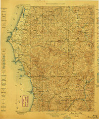
~ Port Orford OR topo map, 1:125000 scale, 30 X 30 Minute, Historical, 1899
Port Orford, Oregon, USGS topographic map dated 1899.
Includes geographic coordinates (latitude and longitude). This topographic map is suitable for hiking, camping, and exploring, or framing it as a wall map.
Printed on-demand using high resolution imagery, on heavy weight and acid free paper, or alternatively on a variety of synthetic materials.
Topos available on paper, Waterproof, Poly, or Tyvek. Usually shipping rolled, unless combined with other folded maps in one order.
- Product Number: USGS-5686395
- Free digital map download (high-resolution, GeoPDF): Port Orford, Oregon (file size: 12 MB)
- Map Size: please refer to the dimensions of the GeoPDF map above
- Weight (paper map): ca. 55 grams
- Map Type: POD USGS Topographic Map
- Map Series: HTMC
- Map Verison: Historical
- Cell ID: 66371
- Scan ID: 283241
- Survey Year: 1898
- Datum: Unstated
- Map Projection: Unstated
- Map published by United States Geological Survey
- Keywords: Overedge with No Adjacent Map
- Map Language: English
- Scanner Resolution: 600 dpi
- Map Cell Name: Port Orford
- Grid size: 30 X 30 Minute
- Date on map: 1899
- Map Scale: 1:125000
- Geographical region: Oregon, United States
Neighboring Maps:
All neighboring USGS topo maps are available for sale online at a variety of scales.
Spatial coverage:
Topo map Port Orford, Oregon, covers the geographical area associated the following places:
- Bancroft - Gaylord - Illahe - Langlois - Plum Trees - Eckley (historical) - Etelka (historical) - Port Orford - Ophir - Sixes - Agness - Denmark - Powers - Nesika Beach - Lakeport (historical)
- Map Area ID: AREA4342.5-124.5-124
- Northwest corner Lat/Long code: USGSNW43-124.5
- Northeast corner Lat/Long code: USGSNE43-124
- Southwest corner Lat/Long code: USGSSW42.5-124.5
- Southeast corner Lat/Long code: USGSSE42.5-124
- Northern map edge Latitude: 43
- Southern map edge Latitude: 42.5
- Western map edge Longitude: -124.5
- Eastern map edge Longitude: -124


