
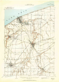
~ Oberlin OH topo map, 1:62500 scale, 15 X 15 Minute, Historical, 1901, updated 1959
Oberlin, Ohio, USGS topographic map dated 1901.
Includes geographic coordinates (latitude and longitude). This topographic map is suitable for hiking, camping, and exploring, or framing it as a wall map.
Printed on-demand using high resolution imagery, on heavy weight and acid free paper, or alternatively on a variety of synthetic materials.
Topos available on paper, Waterproof, Poly, or Tyvek. Usually shipping rolled, unless combined with other folded maps in one order.
- Product Number: USGS-5686337
- Free digital map download (high-resolution, GeoPDF): Oberlin, Ohio (file size: 6 MB)
- Map Size: please refer to the dimensions of the GeoPDF map above
- Weight (paper map): ca. 55 grams
- Map Type: POD USGS Topographic Map
- Map Series: HTMC
- Map Verison: Historical
- Cell ID: 60459
- Scan ID: 227370
- Imprint Year: 1959
- Survey Year: 1901
- Datum: NAD27
- Map Projection: Polyconic
- Map published by United States Geological Survey
- Keywords: Overedge with No Adjacent Map
- Map Language: English
- Scanner Resolution: 600 dpi
- Map Cell Name: Oberlin
- Grid size: 15 X 15 Minute
- Date on map: 1901
- Map Scale: 1:62500
- Geographical region: Ohio, United States
Neighboring Maps:
All neighboring USGS topo maps are available for sale online at a variety of scales.
Spatial coverage:
Topo map Oberlin, Ohio, covers the geographical area associated the following places:
- Kingsleys Corners - Lorain - Riverview Mobile Home Park - South Lorain - Brentwood Lake - Sheffield Lake - Clearview Mobile Park - Shawville (historical) - Abbe Road Trailer Park - Erie West Mobile Home Park - West Ridge Green - Oberlin - Harry's Mobile Home Park - Lake Breeze - Nickelplate (historical) - Laporte - Shoreway Mobile Home Park - Sheffield - Robin Park - Whiskyville - Avon Center - North Ridgeville - Elyria - Ridgewood Mobile Home Park - Eaton Estates - Eaton - Oakpoint (historical) - Vincent - Folger (historical) - Beaver Park - Crandall - Penfield Junction - Westwoods Mobile Home Park - Amherst - Grafton - Shiperd Circle - Coonville - Twin Lakes Homes - Pikewood Manor - Trinity (historical) - Avon - Lakeshore Mobile Homes - Colonial Oaks
- Map Area ID: AREA41.541.25-82.25-82
- Northwest corner Lat/Long code: USGSNW41.5-82.25
- Northeast corner Lat/Long code: USGSNE41.5-82
- Southwest corner Lat/Long code: USGSSW41.25-82.25
- Southeast corner Lat/Long code: USGSSE41.25-82
- Northern map edge Latitude: 41.5
- Southern map edge Latitude: 41.25
- Western map edge Longitude: -82.25
- Eastern map edge Longitude: -82


