
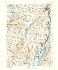
~ Gardiner ME topo map, 1:62500 scale, 15 X 15 Minute, Historical, 1892, updated 1938
Gardiner, Maine, USGS topographic map dated 1892.
Includes geographic coordinates (latitude and longitude). This topographic map is suitable for hiking, camping, and exploring, or framing it as a wall map.
Printed on-demand using high resolution imagery, on heavy weight and acid free paper, or alternatively on a variety of synthetic materials.
Topos available on paper, Waterproof, Poly, or Tyvek. Usually shipping rolled, unless combined with other folded maps in one order.
- Product Number: USGS-5684275
- Free digital map download (high-resolution, GeoPDF): Gardiner, Maine (file size: 9 MB)
- Map Size: please refer to the dimensions of the GeoPDF map above
- Weight (paper map): ca. 55 grams
- Map Type: POD USGS Topographic Map
- Map Series: HTMC
- Map Verison: Historical
- Cell ID: 54483
- Scan ID: 460426
- Imprint Year: 1938
- Survey Year: 1890
- Datum: Unstated
- Map Projection: Polyconic
- Map published by United States Geological Survey
- Map Language: English
- Scanner Resolution: 600 dpi
- Map Cell Name: Gardiner
- Grid size: 15 X 15 Minute
- Date on map: 1892
- Map Scale: 1:62500
- Geographical region: Maine, United States
Neighboring Maps:
All neighboring USGS topo maps are available for sale online at a variety of scales.
Spatial coverage:
Topo map Gardiner, Maine, covers the geographical area associated the following places:
- Spears Corner - Starbird Corner - Bowdoin Center - West Dresden - Pittston - Randolph - Gardiner - Libby Hill - Iceboro - Tacoma - Frenchs Corner - Nehumkeag (historical) - Richmond Corner - South Dresden - Richmond - Harwards - Litchfield Corners - Varney Corner - Purgatory - Hatchs Corner - East Monmouth - South Monmouth - South Gardiner - Bowdoinham - Farmingdale - Batchelders Crossing - Litchfield Plains - Cedar Grove - Browns Corner - Ring Hill
- Map Area ID: AREA44.2544-70-69.75
- Northwest corner Lat/Long code: USGSNW44.25-70
- Northeast corner Lat/Long code: USGSNE44.25-69.75
- Southwest corner Lat/Long code: USGSSW44-70
- Southeast corner Lat/Long code: USGSSE44-69.75
- Northern map edge Latitude: 44.25
- Southern map edge Latitude: 44
- Western map edge Longitude: -70
- Eastern map edge Longitude: -69.75


