
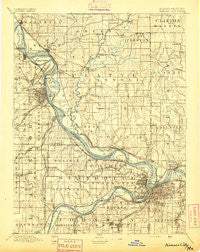
~ Kansas City MO topo map, 1:125000 scale, 30 X 30 Minute, Historical, 1894
Kansas City, Missouri, USGS topographic map dated 1894.
Includes geographic coordinates (latitude and longitude). This topographic map is suitable for hiking, camping, and exploring, or framing it as a wall map.
Printed on-demand using high resolution imagery, on heavy weight and acid free paper, or alternatively on a variety of synthetic materials.
Topos available on paper, Waterproof, Poly, or Tyvek. Usually shipping rolled, unless combined with other folded maps in one order.
- Product Number: USGS-5680369
- Free digital map download (high-resolution, GeoPDF): Kansas City, Missouri (file size: 8 MB)
- Map Size: please refer to the dimensions of the GeoPDF map above
- Weight (paper map): ca. 55 grams
- Map Type: POD USGS Topographic Map
- Map Series: HTMC
- Map Verison: Historical
- Cell ID: 320672
- Scan ID: 325488
- Survey Year: 1887
- Datum: Unstated
- Map Projection: Unstated
- Map published by United States Geological Survey
- Map Language: English
- Scanner Resolution: 600 dpi
- Map Cell Name: Kansas City
- Grid size: 30 X 30 Minute
- Date on map: 1894
- Map Scale: 1:125000
- Geographical region: Missouri, United States
Neighboring Maps:
All neighboring USGS topo maps are available for sale online at a variety of scales.
Spatial coverage:
Topo map Kansas City, Missouri, covers the geographical area associated the following places:
- Winnwood - Clear Creek Court Mobile Home Park - Oakwood Manor - Sunflower Trailer Park - Farley - Victory Junction - Northern Heights - Westport - Maltby - Richardson - Parkdale - Ettenson - Quivira Hills Estates Mobile Home Park - Stillings - Highland - East Leavenworth - Oakwood - Nashua - Turner - Trimble - East Fairmount - South Basehor - Leavenworth - Breen Acres - Creekside Estates Mobile Home Park - American Eagle Mobile Home Estates - Piper - Oaks - Ridgely - Mission - Kansas City - Wadsworth - Min - Rock Village - Weatherby Lake - Fairway - Treasure Parks Creekside Mobile Home Park - Maywood - Iatan - Loring - Tarrytown - Greenwood - Welborn - Tracy - Houston Lake - Bain City - Sunflower - Little Kaw - Wildwoods Mobile Home Park - Parkwood Court Manufactured Home Park - Edwardsville Mobile Home Village - Zarah - Royal Mobile Home Court - Maywood - Kaw View Mobile Home Estates - Winnwood Gardens - Dye - Parkville - Riverside - Wallula - Vinewood - Nearman - Hampton - Hoover - Beverly Hills - Woodruff - Weston - Paradise - North Kansas City - Leeds - Camden Point - Cochrane - Linden - Maple Park - Kansas Trailer Village - Lake of the Forest - Westwood Hills - Woodmoor Mobile Home Park - Tiffany Springs - Hoge - Sadler - Platte Gardens - Mission Hills - Countryside - Grays Park - Grove Center - Kerrville - Basehor - Ferrelview - Platte Woods - Linkville - Harlem - Zoch Trailer Court - Buxton - Milton - Acme - Hiatt - Platte City - Oakwood Park - Chouteau - Woodhill
- Map Area ID: AREA39.539-95-94.5
- Northwest corner Lat/Long code: USGSNW39.5-95
- Northeast corner Lat/Long code: USGSNE39.5-94.5
- Southwest corner Lat/Long code: USGSSW39-95
- Southeast corner Lat/Long code: USGSSE39-94.5
- Northern map edge Latitude: 39.5
- Southern map edge Latitude: 39
- Western map edge Longitude: -95
- Eastern map edge Longitude: -94.5


