
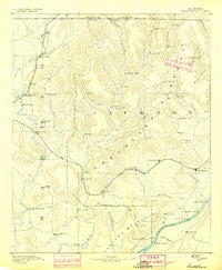
~ Scottsboro AL topo map, 1:125000 scale, 30 X 30 Minute, Historical, 1892
Scottsboro, Alabama, USGS topographic map dated 1892.
Includes geographic coordinates (latitude and longitude). This topographic map is suitable for hiking, camping, and exploring, or framing it as a wall map.
Printed on-demand using high resolution imagery, on heavy weight and acid free paper, or alternatively on a variety of synthetic materials.
Topos available on paper, Waterproof, Poly, or Tyvek. Usually shipping rolled, unless combined with other folded maps in one order.
- Product Number: USGS-5680321
- Free digital map download (high-resolution, GeoPDF): Scottsboro, Alabama (file size: 6 MB)
- Map Size: please refer to the dimensions of the GeoPDF map above
- Weight (paper map): ca. 55 grams
- Map Type: POD USGS Topographic Map
- Map Series: HTMC
- Map Verison: Historical
- Cell ID: 66586
- Scan ID: 305865
- Survey Year: 1885
- Datum: Unstated
- Map Projection: Unstated
- Map published by United States Geological Survey
- Map Language: English
- Scanner Resolution: 600 dpi
- Map Cell Name: Scottsboro
- Grid size: 30 X 30 Minute
- Date on map: 1892
- Map Scale: 1:125000
- Geographical region: Alabama, United States
Neighboring Maps:
All neighboring USGS topo maps are available for sale online at a variety of scales.
Spatial coverage:
Topo map Scottsboro, Alabama, covers the geographical area associated the following places:
- Little Nashville - Mint Spring - Greerton (historical) - Rocky Ridge - Walnut Grove - Beachboro (historical) - Bradford Subdivision - Tupelo - Skyline Shores - Trenton - Scottsboro - Fairview - Preston - Narrows (historical) - Milan (historical) - South Sauty Subdivision - Deposit - Hillsboro - Sauta (historical) - Francisco - Lim Rock - New Hope - Pleasant Hill - Gurley - Owens Cross Roads - Larkinsville - Roseboro - Kyles - Lakeview Shores - Mud Creek (historical) - Hytop - Langston - Jackson Subdivision - Jericho - Breezeway Bay - Lake Shore Drive Subdivision - Lewis Evans Subdivision - Pierceton (historical) - Larkin - Humpton - Goodwin Subdivision - Berkley - Ryland - Jack Lane (historical) - Crossroad - Pikeville - Aspel - Swearengin - Maysville - Saint Clair Store - Letcher - Union Grove - Preston Sights Subdivision - Dry Cove (historical) - Hampton Cove - Hollytree - Nebo - Estillfork - Plevna - Dodsonville (historical) - Cedar Point - Elon - Lowe (historical) - Princeton - Three Forks - Mount Carmel - Roseberry - Swaim - Larkins Fork (historical) - Skyline - Kirbytown - Carver Subdivision - Fannings Crossing - New Hope - Davistown - Padgett (historical) - Oak Grove - Butler Mill - Moontown - Greenfield - Oak Grove - Paint Rock - Sunset (historical) - Buckhorn - Garth - Keel (historical) - Poplar Ridge - Bell Factory - New Market - Berrys (historical) - McCaleb Mill - Cumberland Mountain Farm Colony (historical) - Preston Subdivision - Woodville - Chisenhall Subdivision - Lakeview Beach - Macedonia - Brownsboro - Big Cove - Cherrytree
- Map Area ID: AREA3534.5-86.5-86
- Northwest corner Lat/Long code: USGSNW35-86.5
- Northeast corner Lat/Long code: USGSNE35-86
- Southwest corner Lat/Long code: USGSSW34.5-86.5
- Southeast corner Lat/Long code: USGSSE34.5-86
- Northern map edge Latitude: 35
- Southern map edge Latitude: 34.5
- Western map edge Longitude: -86.5
- Eastern map edge Longitude: -86


