
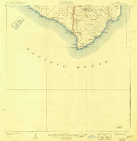
~ Kalae HI topo map, 1:62500 scale, 15 X 15 Minute, Historical, 1924
Kalae, Hawaii, USGS topographic map dated 1924.
Includes geographic coordinates (latitude and longitude). This topographic map is suitable for hiking, camping, and exploring, or framing it as a wall map.
Printed on-demand using high resolution imagery, on heavy weight and acid free paper, or alternatively on a variety of synthetic materials.
Topos available on paper, Waterproof, Poly, or Tyvek. Usually shipping rolled, unless combined with other folded maps in one order.
- Product Number: USGS-5679307
- Free digital map download (high-resolution, GeoPDF): Kalae, Hawaii (file size: 4 MB)
- Map Size: please refer to the dimensions of the GeoPDF map above
- Weight (paper map): ca. 55 grams
- Map Type: POD USGS Topographic Map
- Map Series: HTMC
- Map Verison: Historical
- Cell ID: 55957
- Scan ID: 349861
- Survey Year: 1921
- Datum: Old Hawaiian
- Map Projection: Polyconic
- Map published by United States Geological Survey
- Keywords: Overedge
- Map Language: English
- Scanner Resolution: 600 dpi
- Map Cell Name: Kalae
- Grid size: 15 X 15 Minute
- Date on map: 1924
- Map Scale: 1:62500
- Geographical region: Hawaii, United States
Neighboring Maps:
All neighboring USGS topo maps are available for sale online at a variety of scales.
Spatial coverage:
Topo map Kalae, Hawaii, covers the geographical area associated the following places:
- Kaʻalelā - Puʻumaʻemaʻe - Kalīpoa - Heiau o Molilele - Laeʻokamilo - Kaiʻō - Kaʻaluʻalu Bay - Ka Lae o Hoaiku - Pulehua Island - Hāwea - Luakeananolo - Kaʻahue - Paliʻokūlani - Waiʻahukini Beach - Puʻuohāʻupu - Kahawaikōlono - Kaimuʻuala - Kākio - Kipuka Mali - Kalae - Kaluahonu - Paiahaʻa Bay - Puʻunāhāhā - Kanenelu - ʻEkuokapuaʻa - Lua Makalei - Awāwaloa - Kalepeamoa - Mahana Beach - South Point Park - Kiʻi - Hoonoua - Puʻulohena - Keoneokahuku - Na Ka Puaiakone - Hāliīpālala - Puʻulou - Puāuāomahana - Pohokinikini - Kahuku - Hanalua - Waipouli - Kahiʻo - Puʻukauila - Puhio Kealai - Kaʻilikiʻi Beach (historical) - Pāea - Kaluaokalani - Hāliʻi - Morse Field (historical) - Puʻukaimuʻuala - Kamāoʻa-Puʻuʻeo Hawaiian Home Land - Puʻualiʻi - Puʻuwaimānalo - Waiʻoʻahukini - Kīpukahanalua - Puʻuhou - Kaʻaluʻalu - Kahakahakea - Kāʻalo - Kīpukakuniau - Palihāʻukeʻuke - Kīpukakamao - Heiau o Kalalea - Puʻuʻulaʻula - Paʻakea - Kepuhiokahiʻo Point - Kealakiʻo - Awawa Kahao - Kaulana - Pōhākea - Kamilo Point - Puʻuhuluhulu - Puu Kahakahakea - Luaʻopalahemo - Puʻukoʻihala - ʻŌnikipuka Ridge - Kahiola - ʻŌnikinalu - Kaliʻipaʻa - South Point Air Force Station (historical) - Hāliʻipaʻakai - Lālāhala - Kaulana Bay - Kahaukea - Papakōlea - Waialua - Kamaoa Puueo - Kahukupoko - Puʻumauʻu - Kālolo - Kamilopaekanaka - Kīpukakaʻahue - Kananaka - Kamilopaealiʻi - Mahana Bay - Pōhakuwaʻakauhi - Kaiʻole Bay - Kalaepaʻakai - Kāʻilikiʻi
- Map Area ID: AREA1918.75-155.8333333-155.5833333
- Northwest corner Lat/Long code: USGSNW19-155.8333333
- Northeast corner Lat/Long code: USGSNE19-155.5833333
- Southwest corner Lat/Long code: USGSSW18.75-155.8333333
- Southeast corner Lat/Long code: USGSSE18.75-155.5833333
- Northern map edge Latitude: 19
- Southern map edge Latitude: 18.75
- Western map edge Longitude: -155.8333333
- Eastern map edge Longitude: -155.5833333


