
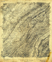
~ Bessemer Special AL topo map, 1:48000 scale, 15 X 15 Minute, Historical, 1905
Bessemer Special, Alabama, USGS topographic map dated 1905.
Includes geographic coordinates (latitude and longitude). This topographic map is suitable for hiking, camping, and exploring, or framing it as a wall map.
Printed on-demand using high resolution imagery, on heavy weight and acid free paper, or alternatively on a variety of synthetic materials.
Topos available on paper, Waterproof, Poly, or Tyvek. Usually shipping rolled, unless combined with other folded maps in one order.
- Product Number: USGS-5678308
- Free digital map download (high-resolution, GeoPDF): Bessemer Special, Alabama (file size: 19 MB)
- Map Size: please refer to the dimensions of the GeoPDF map above
- Weight (paper map): ca. 55 grams
- Map Type: POD USGS Topographic Map
- Map Series: HTMC
- Map Verison: Historical
- Cell ID: 51255
- Scan ID: 305451
- Survey Year: 1905
- Datum: Unstated
- Map Projection: Unstated
- Advance: Yes
- Special Map: Yes
- Map published by United States Geological Survey
- Keywords: Overedge; Nonstandard Press Run
- Map Language: English
- Scanner Resolution: 600 dpi
- Map Cell Name: Bessemer Iron District
- Grid size: 15 X 15 Minute
- Date on map: 1905
- Map Scale: 1:48000
- Geographical region: Alabama, United States
Neighboring Maps:
All neighboring USGS topo maps are available for sale online at a variety of scales.
Spatial coverage:
Topo map Bessemer Special, Alabama, covers the geographical area associated the following places:
- Regent Forest Estates - Blueberry Estates - English Village - Russet Woods - Plantation Point - Rutledge Springs - Harlem Heights - Dolomite - Woodward - Edgemont - Roebuck - Old Jonesboro - Rocky Ridge Manor - Shadywood - Country Club Highlands - Hillman Gardens - Vesclub Estates - Indian Springs Village - Port South - Forest Ridge Estates - Windsor Highlands - Ridgecrest - Stonebrook Park - Ivanhoe - Hunters Glen (historical) - Timbercrest - Rockdale - Bessemer Homestead - New Hill - Montreat - Dearing Downs - Hollywood - Shady Acres Estates - Hilltop - Ishkooda - Hickory Ridge Estates - Beacon Hills - Collins - Ensley Junction - Coalmont - Cherokee Beach - Eastern Valley - Shady Brook Estates - Blue Ridge Estates - Indian Lake Estates - Acton - Hidden Ridge - Verdue Knolls - Bon-Air - Muscoda - Fungo Hollow - Homewood - Monte-Sano - Jones Valley - Oak Hills - Twin Bridge - Scottrock - Indian Valley - Woodward Estates - Laceys Chapel - Navajo Pines - Pleasant Grove - Brownville - Green Acres - Minniesville - Shades Acres - East Brighton - Walnut Grove - Grasselli - Helena - Coventry - Valley Forge - Lipscomb - Monte D'Oro - Blue Creek Junction - Buena Vista Highlands - Crest Estates - Derby Downs Estates - Cottage Hill - Dolonar Junction - Indian Hills - Roosevelt-Cairo Village - Spaulding - Shades Run - Hillman - Hudson Grove - Scott Crest Subdivision - Kingwood - Powderly Hills - Oxmoor - Brooklane Place - Wilkes - Woodmont - Southwood - Rice - Paramount - Rosedale - Ivy Chase - Sky Ranch - Mason City
- Map Area ID: AREA33.533.25-87-86.75
- Northwest corner Lat/Long code: USGSNW33.5-87
- Northeast corner Lat/Long code: USGSNE33.5-86.75
- Southwest corner Lat/Long code: USGSSW33.25-87
- Southeast corner Lat/Long code: USGSSE33.25-86.75
- Northern map edge Latitude: 33.5
- Southern map edge Latitude: 33.25
- Western map edge Longitude: -87
- Eastern map edge Longitude: -86.75


