
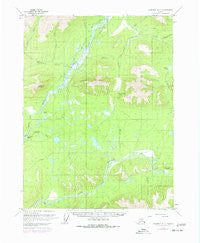
~ Wiseman A 1 AK topo map, 1:63360 scale, 15 X 15 Minute, Historical, 1970, updated 1977
Wiseman A 1, Alaska, USGS topographic map dated 1970.
Includes geographic coordinates (latitude and longitude). This topographic map is suitable for hiking, camping, and exploring, or framing it as a wall map.
Printed on-demand using high resolution imagery, on heavy weight and acid free paper, or alternatively on a variety of synthetic materials.
Topos available on paper, Waterproof, Poly, or Tyvek. Usually shipping rolled, unless combined with other folded maps in one order.
- Product Number: USGS-5675390
- Free digital map download (high-resolution, GeoPDF): Wiseman A 1, Alaska (file size: 15 MB)
- Map Size: please refer to the dimensions of the GeoPDF map above
- Weight (paper map): ca. 55 grams
- Map Type: POD USGS Topographic Map
- Map Series: HTMC
- Map Verison: Historical
- Cell ID: 64659
- Scan ID: 360440
- Imprint Year: 1977
- Woodland Tint: Yes
- Visual Version Number: 1
- Photo Revision Year: 1975
- Aerial Photo Year: 1975
- Datum: NAD27
- Map Projection: Polyconic
- Map published by United States Geological Survey
- Map Language: English
- Scanner Resolution: 600 dpi
- Map Cell Name: Wiseman A-1
- Grid size: 15 X 15 Minute
- Date on map: 1970
- Map Scale: 1:63360
- Geographical region: Alaska, United States
Neighboring Maps:
All neighboring USGS topo maps are available for sale online at a variety of scales.
Spatial coverage:
Topo map Wiseman A 1, Alaska, covers the geographical area associated the following places:
- Lower Fork Twelvemile Creek - Rosie Creek - Tramway Bar - Mailbox Creek - Bear Creek - Eagle Cliff - Porcupine Creek Airport (historical) - Coldfoot Census Designated Place - Upper Fork Twelvemile Creek - Hidden Creek - Cathedral Mountain - Chapman Creek - Porcupine Creek - Myrtle Creek - Sitkum Pass - Twelvemile Creek - Wilson Creek - Chapman Island - Windy Arm - Twelvemile Mountain - Rosie Creek Pass
- Map Area ID: AREA67.2567-150.5-150
- Northwest corner Lat/Long code: USGSNW67.25-150.5
- Northeast corner Lat/Long code: USGSNE67.25-150
- Southwest corner Lat/Long code: USGSSW67-150.5
- Southeast corner Lat/Long code: USGSSE67-150
- Northern map edge Latitude: 67.25
- Southern map edge Latitude: 67
- Western map edge Longitude: -150.5
- Eastern map edge Longitude: -150


