
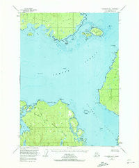
~ Petersburg B 4 AK topo map, 1:63360 scale, 15 X 15 Minute, Historical, 1949, updated 1972
Petersburg B 4, Alaska, USGS topographic map dated 1949.
Includes geographic coordinates (latitude and longitude). This topographic map is suitable for hiking, camping, and exploring, or framing it as a wall map.
Printed on-demand using high resolution imagery, on heavy weight and acid free paper, or alternatively on a variety of synthetic materials.
Topos available on paper, Waterproof, Poly, or Tyvek. Usually shipping rolled, unless combined with other folded maps in one order.
- Product Number: USGS-5671366
- Free digital map download (high-resolution, GeoPDF): Petersburg B 4, Alaska (file size: 12 MB)
- Map Size: please refer to the dimensions of the GeoPDF map above
- Weight (paper map): ca. 55 grams
- Map Type: POD USGS Topographic Map
- Map Series: HTMC
- Map Verison: Historical
- Cell ID: 60910
- Scan ID: 358327
- Imprint Year: 1972
- Woodland Tint: Yes
- Aerial Photo Year: 1948
- Edit Year: 1964
- Datum: NAD27
- Map Projection: Universal Transverse Mercator
- Map published by United States Geological Survey
- Map Language: English
- Scanner Resolution: 600 dpi
- Map Cell Name: Petersburg B-4
- Grid size: 15 X 15 Minute
- Date on map: 1949
- Map Scale: 1:63360
- Geographical region: Alaska, United States
Neighboring Maps:
All neighboring USGS topo maps are available for sale online at a variety of scales.
Spatial coverage:
Topo map Petersburg B 4, Alaska, covers the geographical area associated the following places:
- California Bay - Creek Number One - The Eye Opener Light - Rookery Islands - Level Islands - Point Colpoys - Moss Island - Danger Island - Macnamara Point - Creek Number 1 - Creek Number Two - Bay Point - White Rock - Creek Number Three - Sandy Bight - Creek Number Four - Vichnefski Rock - Pine Creek - Salmon Bay - Red Bay - Salmon Creek - Flat Island - Pine Point - McArthur Reef - Bell Island - Tide Island - Little Level Island - Round Island - Point Saint John - Short Creek - Dead Island - Douglas Bay - Salmon Creek - Mitchell Point - Big Level Island - Creek Number 4 - Narrow Creek - Creek Number 3 - Creek Number 2
- Map Area ID: AREA56.556.25-133.3333333-133
- Northwest corner Lat/Long code: USGSNW56.5-133.3333333
- Northeast corner Lat/Long code: USGSNE56.5-133
- Southwest corner Lat/Long code: USGSSW56.25-133.3333333
- Southeast corner Lat/Long code: USGSSE56.25-133
- Northern map edge Latitude: 56.5
- Southern map edge Latitude: 56.25
- Western map edge Longitude: -133.3333333
- Eastern map edge Longitude: -133


