
~ Philip Smith Mountains AK topo map, 1:250000 scale, 1 X 3 Degree, Historical, 1956, updated 1965
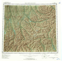
Philip Smith Mountains, Alaska, USGS topographic map dated 1956.
Includes geographic coordinates (latitude and longitude). This topographic map is suitable for hiking, camping, and exploring, or framing it as a wall map.
Printed on-demand using high resolution imagery, on heavy weight and acid free paper, or alternatively on a variety of synthetic materials.
Topos available on paper, Waterproof, Poly, or Tyvek. Usually shipping rolled, unless combined with other folded maps in one order.
- Product Number: USGS-5661746
- Free digital map download (high-resolution, GeoPDF): Philip Smith Mountains, Alaska (file size: 51 MB)
- Map Size: please refer to the dimensions of the GeoPDF map above
- Weight (paper map): ca. 55 grams
- Map Type: POD USGS Topographic Map
- Map Series: HTMC
- Map Verison: Historical
- Cell ID: 68959
- Scan ID: 361293
- Imprint Year: 1965
- Aerial Photo Year: 1955
- Edit Year: 1965
- Datum: NAD27
- Map Projection: Universal Transverse Mercator
- Map published by United States Geological Survey
- Map Language: English
- Scanner Resolution: 600 dpi
- Map Cell Name: Philip Smith Mountains
- Grid size: 1 X 3 Degree
- Date on map: 1956
- Map Scale: 1:250000
- Geographical region: Alaska, United States
Neighboring Maps:
All neighboring USGS topo maps are available for sale online at a variety of scales.
Spatial coverage:
Topo map Philip Smith Mountains, Alaska, covers the geographical area associated the following places:
- Atigun River - Toolik Camp Landing Strip (historical) - Oksrukuyik - Itikmalak River - James Dalton Mountain - Imnavait Mountain - Inikaklik Creek - Cloud Peak - Galbraith Lake - Victor Gulch - Toolik Lake Camp - Slope Mountain - Atigun Gorge - Itkillik Lake - Atigun Pass - Itigaknit Lake - Chandalar Shelf Airport - Section Creek - Beaucoup Creek - Ribdon River - Elusive Lake - Galbraith Lake Camp - Windy Glacier - Itigaknit Mountain - Galbraith Lake Airport - Philip Smith Mountains - Toolik Lake - Oolah Valley - Seefar Glacier - Kakuktukruich Bluff - Chandalar Shelf - Accomplishment Creek
- Map Area ID: AREA6968-150-147
- Northwest corner Lat/Long code: USGSNW69-150
- Northeast corner Lat/Long code: USGSNE69-147
- Southwest corner Lat/Long code: USGSSW68-150
- Southeast corner Lat/Long code: USGSSE68-147
- Northern map edge Latitude: 69
- Southern map edge Latitude: 68
- Western map edge Longitude: -150
- Eastern map edge Longitude: -147


