
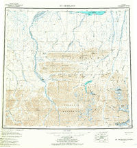
~ Mt Michelson AK topo map, 1:250000 scale, 1 X 3 Degree, Historical, 1956, updated 1967
Mt Michelson, Alaska, USGS topographic map dated 1956.
Includes geographic coordinates (latitude and longitude). This topographic map is suitable for hiking, camping, and exploring, or framing it as a wall map.
Printed on-demand using high resolution imagery, on heavy weight and acid free paper, or alternatively on a variety of synthetic materials.
Topos available on paper, Waterproof, Poly, or Tyvek. Usually shipping rolled, unless combined with other folded maps in one order.
- Product Number: USGS-5661570
- Free digital map download (high-resolution, GeoPDF): Mt Michelson, Alaska (file size: 27 MB)
- Map Size: please refer to the dimensions of the GeoPDF map above
- Weight (paper map): ca. 55 grams
- Map Type: POD USGS Topographic Map
- Map Series: HTMC
- Map Verison: Historical
- Cell ID: 68924
- Scan ID: 361207
- Imprint Year: 1967
- Aerial Photo Year: 1956
- Survey Year: 1955
- Datum: NAD27
- Map Projection: Universal Transverse Mercator
- Map published by United States Geological Survey
- Map Language: English
- Scanner Resolution: 600 dpi
- Map Cell Name: Mount Michelson
- Grid size: 1 X 3 Degree
- Date on map: 1956
- Map Scale: 1:250000
- Geographical region: Alaska, United States
Neighboring Maps:
All neighboring USGS topo maps are available for sale online at a variety of scales.
Spatial coverage:
Topo map Mt Michelson, Alaska, covers the geographical area associated the following places:
- Straight Creek - Neruokpuk Lakes - James Robert Glacier - Itkilyariak Valley - Nanook Creek - Brown Low Point Airport (historical) - Fourth Range - Weller Creek - Last Creek - Camp 263 Creek - Ledge Creek - West Fork Marsh Creek - Canning Valley - Lake Peters - Ignek Valley - Whistler Creek - Pogopuk Creek - Eagle Creek - Sadlerochit Mountains - Limit Creek - Mount Michelson - Chamberlin Glacier - Sadlerochit Valley - Spawning Creek - Sunset Pass - Kulavok Ridge - Ikiakpuk Valley - Esetuk Glacier - Mount Weller - Shubelik Mountains - Cache Creek - Mount Mary - Fire Creek - Red Hill - Mount Pangnik - Kekiktuk River - Hue Creek - Okiotak Peak - Itkilyariak Creek - Gravel Creek - Okpilak Valley - Kolotuk Creek - Itkillik Creek - Carter Creek - Black Dog Creek - Franklin Creek - Salisbury Creek - Cobble Creek - Talus Creek - Chamberlin Creek - Carnivore Creek - Mount Copleston - Kelly Ridge - Prudhoe Bay-Kaktovik Census Subarea (historical) - Pangnik Glacier - Okpilak Glacier - Snow Creek - West Nularvik Creek - Karen Creek - Fossil Creek - Arey Creek - Marsh Fork Canning River - West Patuk Creek - Marsh Creek - Third Range - Coke Creek - Kingak Hill - Mary Range - Shublik Spring - Mount Chamberlin - Kaviak Creek - Katakturuk River - Split Creek - Nularvik River - Lake Schrader - Kikiktat Mountain - G William Holmes Research Station - Franklin Mountains - Old Woman Creek - Black Island - Tugak Peak - Leffingwell Creek - Mount Salisbury - Sadlerochit Spring - Ignek Creek - East Nularvik Creek - Arctic Creek - East Patuk Creek - Collinson Point - Katak Creek - Curve Creek - Ikiakpaurak Valley - Plunge Creek - Old Man Creek - Simpson Cove - Split Glacier - Okpilak Lake - Dodo Creek - Kingak Cliff - James Robert Lake
- Map Area ID: AREA7069-147-144
- Northwest corner Lat/Long code: USGSNW70-147
- Northeast corner Lat/Long code: USGSNE70-144
- Southwest corner Lat/Long code: USGSSW69-147
- Southeast corner Lat/Long code: USGSSE69-144
- Northern map edge Latitude: 70
- Southern map edge Latitude: 69
- Western map edge Longitude: -147
- Eastern map edge Longitude: -144


