
~ Anchorage AK topo map, 1:250000 scale, 1 X 3 Degree, Historical, 1962, updated 1966
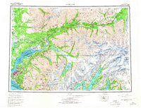
Anchorage, Alaska, USGS topographic map dated 1962.
Includes geographic coordinates (latitude and longitude). This topographic map is suitable for hiking, camping, and exploring, or framing it as a wall map.
Printed on-demand using high resolution imagery, on heavy weight and acid free paper, or alternatively on a variety of synthetic materials.
Topos available on paper, Waterproof, Poly, or Tyvek. Usually shipping rolled, unless combined with other folded maps in one order.
- Product Number: USGS-5660340
- Free digital map download (high-resolution, GeoPDF): Anchorage, Alaska (file size: 41 MB)
- Map Size: please refer to the dimensions of the GeoPDF map above
- Weight (paper map): ca. 55 grams
- Map Type: POD USGS Topographic Map
- Map Series: HTMC
- Map Verison: Historical
- Cell ID: 72214
- Scan ID: 361715
- Imprint Year: 1966
- Woodland Tint: Yes
- Survey Year: 1962
- Datum: NAD27
- Map Projection: Universal Transverse Mercator
- Map published by United States Geological Survey
- Map Language: English
- Scanner Resolution: 600 dpi
- Map Cell Name: Anchorage
- Grid size: 1 X 3 Degree
- Date on map: 1962
- Map Scale: 1:250000
- Geographical region: Alaska, United States
Neighboring Maps:
All neighboring USGS topo maps are available for sale online at a variety of scales.
Spatial coverage:
Topo map Anchorage, Alaska, covers the geographical area associated the following places:
- Nunaka Valley - Justamere Ranch - Chickaloon - Tuomi - Lange - Rainbow - City View - Wasilla - Bonibrook - Chugiak - Hillside - Gateway - Nels Klevens - Rees - Turnagain Heights - DeBarr Vista - Anchor Terrace - Birchwood - Fairview - Glen Alps - Blanchard - Big Lake - Lazy Mountain - Lawrence - Matanuska - Jonesville - Fort Richardson - Romig - Airport Heights - Wonder Park - Cottonwood - Chugach Heights - Eklutna - Big Lake - Houston - Spenard - Knik Heights - John Fitzgerald Kennedy City - Peters Creek - Eagle River - Campbell - Butte - Rogers Park - Meadow Lakes - East Chester - Knik - Potter Hill - Lucky Shot Landing - Homesite Park - Grandview Gardens - Artesian Village - Wilson Village - Tanaina - Mountain View - Lindale - Palmer - Rogers Park - Lingo - Eureka Roadhouse - Vanover - Runstettler - Point MacKenzie - Anchorage - Basher - Green Acres - Sunbeam - Chester - Eska - Thompson - Traversie - Sutton
- Map Area ID: AREA6261-150-147
- Northwest corner Lat/Long code: USGSNW62-150
- Northeast corner Lat/Long code: USGSNE62-147
- Southwest corner Lat/Long code: USGSSW61-150
- Southeast corner Lat/Long code: USGSSE61-147
- Northern map edge Latitude: 62
- Southern map edge Latitude: 61
- Western map edge Longitude: -150
- Eastern map edge Longitude: -147


