
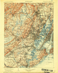
~ Passaic NJ topo map, 1:125000 scale, 30 X 30 Minute, Historical, 1905, updated 1913
Passaic, New Jersey, USGS topographic map dated 1905.
Includes geographic coordinates (latitude and longitude). This topographic map is suitable for hiking, camping, and exploring, or framing it as a wall map.
Printed on-demand using high resolution imagery, on heavy weight and acid free paper, or alternatively on a variety of synthetic materials.
Topos available on paper, Waterproof, Poly, or Tyvek. Usually shipping rolled, unless combined with other folded maps in one order.
- Product Number: USGS-5658978
- Free digital map download (high-resolution, GeoPDF): Passaic, New Jersey (file size: 12 MB)
- Map Size: please refer to the dimensions of the GeoPDF map above
- Weight (paper map): ca. 55 grams
- Map Type: POD USGS Topographic Map
- Map Series: HTMC
- Map Verison: Historical
- Cell ID: 66431
- Scan ID: 255444
- Imprint Year: 1913
- Survey Year: 1903
- Datum: Unstated
- Map Projection: Unstated
- Map published by United States Geological Survey
- Keywords: Overedge
- Map Language: English
- Scanner Resolution: 600 dpi
- Map Cell Name: Passaic
- Grid size: 30 X 30 Minute
- Date on map: 1905
- Map Scale: 1:125000
- Geographical region: New Jersey, United States
Neighboring Maps:
All neighboring USGS topo maps are available for sale online at a variety of scales.
Spatial coverage:
Topo map Passaic, New Jersey, covers the geographical area associated the following places:
- The Village at Little Falls - Linden-Park - Eltingville - Wallington - Riverside Terrace - Tribeca - Newark Heights - Malapardis - Christopher Columbus Homes - Stapleton - Clinton - Orange - Cedar Knolls - Woodland Park - New Providence - West Englewood - Park Village - Fresh Kills - Watchung - Essex Fells - Netherwood - Lodi - Greenville - Hillside - Belleville - Lake View - Lake Parsippany - Union City - Clifton - North Bergen - Wortendyke - Warrenville - Arcola - Washingtonville - Newark - Richmond - Stony Hill - Tremont Park - William Dunlap Homes - Goodmans Crossing - Roseland - Riverview Manor - Travis - Clark - New York - Brantwood - Westwood - Irvington - Rochelle Park - Woodrow - Oakwood - Red Hook Houses - Staten Island - Port Reading - Garwood - Oak Tree - Bloomfield - Red Hook - Elmwood Park - Greenridge - Hickory Tree - Morristown - Chrome - Woods of Arden - Garfield - Llewellyn Park - West Village Houses - Staten Island Junction - Bonhamtown - Verona - Bay Ridge - Metropolitan Mobile Home Park - Bulls Head - Unionburg - Allwood - Fox Hill - Princes Bay - Gillette - Ridgefield - Elmora - Prospect Park - Sewaren - Hasbrouck Heights - New Dorp - Boonton - Athenia - Fayson Lakes - Livingston - Oradell - Montville - Lake Hiawatha - Shady Lawn Manor - South Beach - Madison Hill - Middlesex - Caldwell - Short Hills - Plainfield - White Oak Ridge - Loantaka Estates
- Map Area ID: AREA4140.5-74.5-74
- Northwest corner Lat/Long code: USGSNW41-74.5
- Northeast corner Lat/Long code: USGSNE41-74
- Southwest corner Lat/Long code: USGSSW40.5-74.5
- Southeast corner Lat/Long code: USGSSE40.5-74
- Northern map edge Latitude: 41
- Southern map edge Latitude: 40.5
- Western map edge Longitude: -74.5
- Eastern map edge Longitude: -74


