
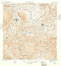
~ Ciales PR topo map, 1:30000 scale, 7.5 X 7.5 Minute, Historical, 1946
Ciales, Puerto Rico, USGS topographic map dated 1946.
Includes geographic coordinates (latitude and longitude). This topographic map is suitable for hiking, camping, and exploring, or framing it as a wall map.
Printed on-demand using high resolution imagery, on heavy weight and acid free paper, or alternatively on a variety of synthetic materials.
Topos available on paper, Waterproof, Poly, or Tyvek. Usually shipping rolled, unless combined with other folded maps in one order.
- Product Number: USGS-5655228
- Free digital map download (high-resolution, GeoPDF): Ciales, Puerto Rico (file size: 12 MB)
- Map Size: please refer to the dimensions of the GeoPDF map above
- Weight (paper map): ca. 55 grams
- Map Type: POD USGS Topographic Map
- Map Series: HTMC
- Map Verison: Historical
- Cell ID: 7970
- Scan ID: 362381
- Datum: Puerto Rico
- Map Projection: Polyconic
- Map published by United States Geological Survey
- Map Language: English
- Scanner Resolution: 600 dpi
- Map Cell Name: Central La Plata
- Grid size: 7.5 X 7.5 Minute
- Date on map: 1946
- Map Scale: 1:30000
- Geographical region: Puerto Rico, United States
Neighboring Maps:
All neighboring USGS topo maps are available for sale online at a variety of scales.
Spatial coverage:
Topo map Ciales, Puerto Rico, covers the geographical area associated the following places:
- Hacienda Alicia - Josefa - San Lorenzo - Hacienda Casey - El Espino - Finca San Miguel - Aquilino - Hacienda Morales - Isleta - Hato Arriba - Hacienda Mata - Espino - Hato Arriba Comunidad - Espino Comunidad - Mata y Orsini - La Parada - Hacienda Lamberti - Hacienda Esperanza
- Map Area ID: AREA18.37518.25-67.125-67
- Northwest corner Lat/Long code: USGSNW18.375-67.125
- Northeast corner Lat/Long code: USGSNE18.375-67
- Southwest corner Lat/Long code: USGSSW18.25-67.125
- Southeast corner Lat/Long code: USGSSE18.25-67
- Northern map edge Latitude: 18.375
- Southern map edge Latitude: 18.25
- Western map edge Longitude: -67.125
- Eastern map edge Longitude: -67


