
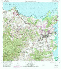
~ Fajardo PR topo map, 1:20000 scale, 7.5 X 7.5 Minute, Historical, 1962, updated 1989
Fajardo, Puerto Rico, USGS topographic map dated 1962.
Includes geographic coordinates (latitude and longitude). This topographic map is suitable for hiking, camping, and exploring, or framing it as a wall map.
Printed on-demand using high resolution imagery, on heavy weight and acid free paper, or alternatively on a variety of synthetic materials.
Topos available on paper, Waterproof, Poly, or Tyvek. Usually shipping rolled, unless combined with other folded maps in one order.
- Product Number: USGS-5654734
- Free digital map download (high-resolution, GeoPDF): Fajardo, Puerto Rico (file size: 24 MB)
- Map Size: please refer to the dimensions of the GeoPDF map above
- Weight (paper map): ca. 55 grams
- Map Type: POD USGS Topographic Map
- Map Series: HTMC
- Map Verison: Historical
- Cell ID: 14906
- Scan ID: 362414
- Imprint Year: 1989
- Woodland Tint: Yes
- Visual Version Number: 1
- Photo Revision Year: 1982
- Aerial Photo Year: 1977
- Edit Year: 1982
- Field Check Year: 1942
- Datum: Puerto Rico
- Map Projection: Polyconic
- Map published by United States Geological Survey
- Map Language: English
- Scanner Resolution: 600 dpi
- Map Cell Name: Fajardo
- Grid size: 7.5 X 7.5 Minute
- Date on map: 1962
- Map Scale: 1:20000
- Geographical region: Puerto Rico, United States
Neighboring Maps:
All neighboring USGS topo maps are available for sale online at a variety of scales.
Spatial coverage:
Topo map Fajardo, Puerto Rico, covers the geographical area associated the following places:
- Santa Rita - Boquerón - Playa Fortuna - Villa Clarita - Comunidad Villa Angelina - Barriada Viera - San Pedro - Borrás - Playa de Fajardo - Soroco - Luquillo Mar - Aldea Cintrón - Santa Isidra 2 Extenstion - Vista Del Mar - Las Croabas - Reparto Valle Verde - Luis M. Cintron - Boulevarda Montanez - Vega Baja - Fajardo Zona Urbana - Mabí - Residencial Puerto Real - Luquillo Lomas - Playa Azul - Garcia Ponce - Luis Cintrón - Vista del Convento - Brisas del Mar - Convento - Paulina - Solimar - Casa Blanca - Fajardo Gardens - Baralt - Santa Isidra - Residencial El Yuquiyu - Espanta Sueño - Vapor - Valle Puerto Real - Santa Isidra I Extension - Playa Fortuna Comunidad - Villas de Puerto Rico - Josefa - Villa Fajardo I - Vistas de Luquillo - Vilomar - Residencial El Cemi - Ramos - Playa Sardinera - Alhambra Jerusalem - Pitahaya - San Vicente - Los Colinas Santa Maria - Monserrate - Paraíso - Beltrán - Ramos Comunidad - Sabana - Reparto La Playa - Fortuna - Boulevarda Roosevelt - Isidra - Luquillo - Sandy Hills - Fortuna - Saldaña - Melendez - Yuquiyú - Monte Brisas - Luquillo Zona Urbana - Alamar - Las Croabas Comunidad - San Pedro - San Miguel - Margarita - Luis M. Cintrón Comunidad - Costal Azul - Fajardo
- Map Area ID: AREA18.418.275-65.75-65.625
- Northwest corner Lat/Long code: USGSNW18.4-65.75
- Northeast corner Lat/Long code: USGSNE18.4-65.625
- Southwest corner Lat/Long code: USGSSW18.275-65.75
- Southeast corner Lat/Long code: USGSSE18.275-65.625
- Northern map edge Latitude: 18.4
- Southern map edge Latitude: 18.275
- Western map edge Longitude: -65.75
- Eastern map edge Longitude: -65.625


