
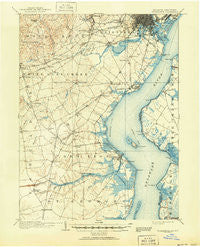
~ Wilmington DE topo map, 1:62500 scale, 15 X 15 Minute, Historical, 1906, updated 1951
Wilmington, Delaware, USGS topographic map dated 1906.
Includes geographic coordinates (latitude and longitude). This topographic map is suitable for hiking, camping, and exploring, or framing it as a wall map.
Printed on-demand using high resolution imagery, on heavy weight and acid free paper, or alternatively on a variety of synthetic materials.
Topos available on paper, Waterproof, Poly, or Tyvek. Usually shipping rolled, unless combined with other folded maps in one order.
- Product Number: USGS-5647721
- Free digital map download (high-resolution, GeoPDF): Wilmington, Delaware (file size: 8 MB)
- Map Size: please refer to the dimensions of the GeoPDF map above
- Weight (paper map): ca. 55 grams
- Map Type: POD USGS Topographic Map
- Map Series: HTMC
- Map Verison: Historical
- Cell ID: 64586
- Scan ID: 255808
- Imprint Year: 1951
- Survey Year: 1904
- Datum: Unstated
- Map Projection: Polyconic
- Map published by United States Geological Survey
- Keywords: Overedge
- Map Language: English
- Scanner Resolution: 600 dpi
- Map Cell Name: Wilmington
- Grid size: 15 X 15 Minute
- Date on map: 1906
- Map Scale: 1:62500
- Geographical region: Delaware, United States
Neighboring Maps:
All neighboring USGS topo maps are available for sale online at a variety of scales.
Spatial coverage:
Topo map Wilmington, Delaware, covers the geographical area associated the following places:
- Swanwyck - Stanton - Sheridan Square - Stanton Estates - Albion - Boxwood - West Minquadale - Swanwyck Gardens - Wilmington Manor - Leedon Estates - Stones Throw - Piermont Woods - Woodshade - Linden Hill - Prices Corner - Linden Green Apartment - Delaware City - Woodcreek - Meadowbrook Farms South - Green Valley - Fairway Falls - Kiamensi Heights - Middleboro Crest - Cedar Farms - Colonial Village Apartments - Duncan Village - Wrangle Hill - Drummond Ridge - Mayview Manor - Rogers Corners - Central Park - Salem Woods - Keystone - Oakmont - Pendrew Manor - Kings Croft - Arundel - Landers Park - Pleasantville - Greenleaf Manor - Rutherford - Heather Woods - Pike Creek - Garwood Estates - Milford Crossroads - Coventry - Marshallton Heights II - Albertson Park - Elsmere - Mount Pleasant Mobile Home Park - West Meadow - Brookland Terrace - Duross Heights - Duross Heights - Yorkshire - Skyline Crest - Concord Towers - Deacons Walk - Cavaliers Country Club Apartments - Simonds Gardens - The Cedars - Riveredge Park - Saint Georges Heights - Pleasant Hill - Salem Village - Cleland Heights - Taylortown - Hamilton Park - Rolling Meadows - Champlin Village - The Bluffs - Chelsea Estates - Cedar Heights - Pencader Village - Westfield - Heritage - Washington Heights - Brookbend - Pine Swamp Corner - Fern Hook - Hares Corner - Colony Hills - Victoria Woods - Airmont Acres - Millside - Henderson Heights - Tolham Estates - Buttonwood - Brandywine Springs - Cooper Farm - The Village of Drummond Hill - Corner Ketch - Stage Road Development - Reybold - Robscott Manor - Canby Park Estates - Latimer Estates - Weatherhill Farms - Pennsville - Holloway Terrace
- Map Area ID: AREA39.7539.5-75.75-75.5
- Northwest corner Lat/Long code: USGSNW39.75-75.75
- Northeast corner Lat/Long code: USGSNE39.75-75.5
- Southwest corner Lat/Long code: USGSSW39.5-75.75
- Southeast corner Lat/Long code: USGSSE39.5-75.5
- Northern map edge Latitude: 39.75
- Southern map edge Latitude: 39.5
- Western map edge Longitude: -75.75
- Eastern map edge Longitude: -75.5


