
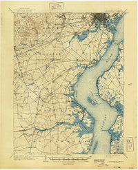
~ Wilmington DE topo map, 1:62500 scale, 15 X 15 Minute, Historical, 1906, updated 1944
Wilmington, Delaware, USGS topographic map dated 1906.
Includes geographic coordinates (latitude and longitude). This topographic map is suitable for hiking, camping, and exploring, or framing it as a wall map.
Printed on-demand using high resolution imagery, on heavy weight and acid free paper, or alternatively on a variety of synthetic materials.
Topos available on paper, Waterproof, Poly, or Tyvek. Usually shipping rolled, unless combined with other folded maps in one order.
- Product Number: USGS-5647719
- Free digital map download (high-resolution, GeoPDF): Wilmington, Delaware (file size: 9 MB)
- Map Size: please refer to the dimensions of the GeoPDF map above
- Weight (paper map): ca. 55 grams
- Map Type: POD USGS Topographic Map
- Map Series: HTMC
- Map Verison: Historical
- Cell ID: 64586
- Scan ID: 255806
- Imprint Year: 1944
- Survey Year: 1904
- Datum: Unstated
- Map Projection: Polyconic
- Map published by United States Geological Survey
- Keywords: Overedge
- Map Language: English
- Scanner Resolution: 600 dpi
- Map Cell Name: Wilmington
- Grid size: 15 X 15 Minute
- Date on map: 1906
- Map Scale: 1:62500
- Geographical region: Delaware, United States
Neighboring Maps:
All neighboring USGS topo maps are available for sale online at a variety of scales.
Spatial coverage:
Topo map Wilmington, Delaware, covers the geographical area associated the following places:
- Little Jersey - Gams Crest - Fox Chase Park - Lakecroft II - Chestnut Hill Estates - Elmwood - Claridge Court - Milltown - Porter - Wilmington Manor Gardens - Tybrook - Summer Hill - Deacons Walk - Cranston Heights - Scarborough Park - Washington Park - Oakmont - Avalon - Leedon Estates - Varlano - Tybouts Corner - Lums Pond Estates II - Mahoneyville - Fairwinds Mobile Home Park - Edgebrooke - Minquadale Trailer Village - Ashley - Pike Creek Valley - Greenbridge - Milford Crossroads - Limestone Gardene - Linden Heath - Shenandoah - Greenbank - Swanwyck Estates - Greenleaf Manor - Forest Brook Glen - Birds Corner - Mermaid - Tolham Estates - Faulkland Woods - Washington Heights - Faulkland - Whilton - Glendale - New Castle - The Villa - Boxwood - Victoria Woods - Harmony - Cherokee Woods - Centennial Village - Woodland Park - Stockton - Rolling Meadows - Wilmington - Pennsville - The Hills of Skyline - Woodside Manor - Clearfield - Llangollen Estates - Woodland - Newark Oaks - Castle Hills - Elmhurst - Penn Acres - The Cedars - Fort Elfsborg - Hares Corner - Westview - Rosegate - Sherwood Park - Lyndalia - Liberty - Middleboro East - Christiana - Wrange Hill Estates - Farnhurst - Glenville - Harmony Hills - Fairway Falls - Cavaliers Country Club Apartments - Brookside - Dutch Neck Farms - Drummond Ridge - Capital Trail Farms - Wilson - Eastburn Heights - Biddles Corner - Mount Pleasant - Hickory Woods - Roseville Park - Middleboro Crest - Rambleton Acres - Heritage - Garfield Park - Catalina Gardens - Rivers End - Stanton - Kiamensi Gardens
- Map Area ID: AREA39.7539.5-75.75-75.5
- Northwest corner Lat/Long code: USGSNW39.75-75.75
- Northeast corner Lat/Long code: USGSNE39.75-75.5
- Southwest corner Lat/Long code: USGSSW39.5-75.75
- Southeast corner Lat/Long code: USGSSE39.5-75.5
- Northern map edge Latitude: 39.75
- Southern map edge Latitude: 39.5
- Western map edge Longitude: -75.75
- Eastern map edge Longitude: -75.5


