
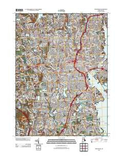
~ Providence RI topo map, 1:24000 scale, 7.5 X 7.5 Minute, Historical, 2012
Providence, Rhode Island, USGS topographic map dated 2012.
Includes geographic coordinates (latitude and longitude). This topographic map is suitable for hiking, camping, and exploring, or framing it as a wall map.
Printed on-demand using high resolution imagery, on heavy weight and acid free paper, or alternatively on a variety of synthetic materials.
Topos available on paper, Waterproof, Poly, or Tyvek. Usually shipping rolled, unless combined with other folded maps in one order.
- Product Number: USGS-5644908
- Free digital map download (high-resolution, GeoPDF): Providence, Rhode Island (file size: 26 MB)
- Map Size: please refer to the dimensions of the GeoPDF map above
- Weight (paper map): ca. 55 grams
- Map Type: POD USGS Topographic Map
- Map Series: US Topo
- Map Verison: Historical
- Cell ID: 36557
- Datum: North American Datum of 1983
- Map Projection: Transverse Mercator
- Map Cell Name: Providence
- Grid size: 7.5 X 7.5 Minute
- Date on map: 2012
- Map Scale: 1:24000
- Geographical region: Rhode Island, United States
Neighboring Maps:
All neighboring USGS topo maps are available for sale online at a variety of scales.
Spatial coverage:
Topo map Providence, Rhode Island, covers the geographical area associated the following places:
- Watchemoket - Lakewood - North Providence - Centerdale - Providence - Pawtuxet - Wayland - Fruit Hill - Edgewood - Elmwood - Olneyville - Auburn - Wanskuck - Christian Hill - Geneva - Cork Hill (historical) - Silver Hook - Oaklawn - Manton - Dyerville - Meshanticut - Norwood - Pettaconsett - Esmond - Wayland (historical) - Woodville - Sockanosset - Hughesdale - Thornton - Pocasset - Allendale - Washington Park - Woodlawn - Garden City - Cranston - Foxes Hill - Fort Hill (historical) - Greystone - Marieville - Lymansville - Knightsville - Silver Lake - Bellefonte (historical) - Merino
- Map Area ID: AREA41.87541.75-71.5-71.375
- Northwest corner Lat/Long code: USGSNW41.875-71.5
- Northeast corner Lat/Long code: USGSNE41.875-71.375
- Southwest corner Lat/Long code: USGSSW41.75-71.5
- Southeast corner Lat/Long code: USGSSE41.75-71.375
- Northern map edge Latitude: 41.875
- Southern map edge Latitude: 41.75
- Western map edge Longitude: -71.5
- Eastern map edge Longitude: -71.375


