
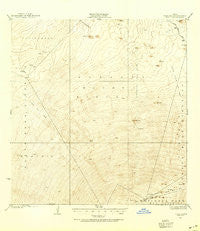
~ Kaohe HI topo map, 1:62500 scale, 15 X 15 Minute, Historical, 1927, updated 1954
Kaohe, Hawaii, USGS topographic map dated 1927.
Includes geographic coordinates (latitude and longitude). This topographic map is suitable for hiking, camping, and exploring, or framing it as a wall map.
Printed on-demand using high resolution imagery, on heavy weight and acid free paper, or alternatively on a variety of synthetic materials.
Topos available on paper, Waterproof, Poly, or Tyvek. Usually shipping rolled, unless combined with other folded maps in one order.
- Product Number: USGS-5644680
- Free digital map download (high-resolution, GeoPDF): Kaohe, Hawaii (file size: 6 MB)
- Map Size: please refer to the dimensions of the GeoPDF map above
- Weight (paper map): ca. 55 grams
- Map Type: POD USGS Topographic Map
- Map Series: HTMC
- Map Verison: Historical
- Cell ID: 55992
- Scan ID: 349864
- Imprint Year: 1954
- Survey Year: 1927
- Datum: Old Hawaiian
- Map Projection: Polyconic
- Map published by United States Geological Survey
- Map Language: English
- Scanner Resolution: 600 dpi
- Map Cell Name: Kaohe
- Grid size: 15 X 15 Minute
- Date on map: 1927
- Map Scale: 1:62500
- Geographical region: Hawaii, United States
Neighboring Maps:
All neighboring USGS topo maps are available for sale online at a variety of scales.
Spatial coverage:
Topo map Kaohe, Hawaii, covers the geographical area associated the following places:
- Pukauahi - Kīpukaʻalalā - Puʻukoʻohi - Keʻāmuku Lava Flow - Mauna Loa Observatory - Puʻuahi - Lava Flow of 1935 - Hawaii County - Lava Flow of 1843 - Lua Ioane - Dewey Cone - Nāʻōhuleʻelua - Waikahalulu Gulch - Puʻukoli - Pōhakuloa Training Area - Steaming Cone - Kaʻohe - Lava Flow of 1859 - Pohakuʻohanalei - Northeast Rift Zone - Nāpuʻukūlua - Mauna Loa Forest Reserve - State of Hawaii - Island of Hawaiʻi - Kōkoʻolau
- Map Area ID: AREA19.7519.5-155.75-155.5
- Northwest corner Lat/Long code: USGSNW19.75-155.75
- Northeast corner Lat/Long code: USGSNE19.75-155.5
- Southwest corner Lat/Long code: USGSSW19.5-155.75
- Southeast corner Lat/Long code: USGSSE19.5-155.5
- Northern map edge Latitude: 19.75
- Southern map edge Latitude: 19.5
- Western map edge Longitude: -155.75
- Eastern map edge Longitude: -155.5


