
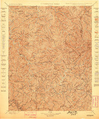
~ Oceana WV topo map, 1:125000 scale, 30 X 30 Minute, Historical, 1898
Oceana, West Virginia, USGS topographic map dated 1898.
Includes geographic coordinates (latitude and longitude). This topographic map is suitable for hiking, camping, and exploring, or framing it as a wall map.
Printed on-demand using high resolution imagery, on heavy weight and acid free paper, or alternatively on a variety of synthetic materials.
Topos available on paper, Waterproof, Poly, or Tyvek. Usually shipping rolled, unless combined with other folded maps in one order.
- Product Number: USGS-5638747
- Free digital map download (high-resolution, GeoPDF): Oceana, West Virginia (file size: 15 MB)
- Map Size: please refer to the dimensions of the GeoPDF map above
- Weight (paper map): ca. 55 grams
- Map Type: POD USGS Topographic Map
- Map Series: HTMC
- Map Verison: Historical
- Cell ID: 395871
- Scan ID: 254000
- Survey Year: 1896
- Datum: Unstated
- Map Projection: Unstated
- Map published by United States Geological Survey
- Map Language: English
- Scanner Resolution: 600 dpi
- Map Cell Name: Oceana
- Grid size: 30 X 30 Minute
- Date on map: 1898
- Map Scale: 1:125000
- Geographical region: West Virginia, United States
Neighboring Maps:
All neighboring USGS topo maps are available for sale online at a variety of scales.
Spatial coverage:
Topo map Oceana, West Virginia, covers the geographical area associated the following places:
- Ramage - Mohawk - Fanny - War Eagle - Clinton - Guyan - Marnie - Lynco - Bruno - Brenton - Sodom - Packsville - Havana - Janie - Sharon Heights - Sabine - Kistler - Edwight - Edith - Dobra - Stollings - Windom - Omar - Cazy - Keyrock - Lillyhaven - Bob White - Fanrock - Marfork - Toney Fork - Crites - Matheny - Justice Addition - McConnell - Mifflin - Hetzel - Secoal - Slabtown - Micco - Greenwood - Gillman Bottom - Verner - Sovereign - Pondco - Mineral City - Ralumco - Uno - Steeles - Wyoming City - Anchor - Red Campbell - Clear Fork - Ikes Fork - Jesse - Wharton - Horsepen (historical) - Crooked Creek - Wharncliffe - Cyclone - Monaville - Christian - Dabney - Jeffrey - Lyburn - Rock View - Glover - Lillydale - Kelly - Kopperston - Wilkinson - Leatherwood - Rum Junction - Lacoma - Lincoln - Yolyn - Mellville - Jackson - Glen Alum Junction - Taplin - Blue Pennant - Echart (historical) - Freeze Fork - Justice - Wanda - Chambers - Orville - Monclo - Oceana - Coal Mountain - Tamcliff - Isom - Mallory - Stoneville - Hampden - Braeholm - Sarah Ann - Sundial - Crystal Block - Elk Run Junction - Clothier
- Map Area ID: AREA3837.5-82-81.5
- Northwest corner Lat/Long code: USGSNW38-82
- Northeast corner Lat/Long code: USGSNE38-81.5
- Southwest corner Lat/Long code: USGSSW37.5-82
- Southeast corner Lat/Long code: USGSSE37.5-81.5
- Northern map edge Latitude: 38
- Southern map edge Latitude: 37.5
- Western map edge Longitude: -82
- Eastern map edge Longitude: -81.5


