
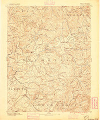
~ Nicholas WV topo map, 1:125000 scale, 30 X 30 Minute, Historical, 1889
Nicholas, West Virginia, USGS topographic map dated 1889.
Includes geographic coordinates (latitude and longitude). This topographic map is suitable for hiking, camping, and exploring, or framing it as a wall map.
Printed on-demand using high resolution imagery, on heavy weight and acid free paper, or alternatively on a variety of synthetic materials.
Topos available on paper, Waterproof, Poly, or Tyvek. Usually shipping rolled, unless combined with other folded maps in one order.
- Product Number: USGS-5638733
- Free digital map download (high-resolution, GeoPDF): Nicholas, West Virginia (file size: 9 MB)
- Map Size: please refer to the dimensions of the GeoPDF map above
- Weight (paper map): ca. 55 grams
- Map Type: POD USGS Topographic Map
- Map Series: HTMC
- Map Verison: Historical
- Cell ID: 395867
- Scan ID: 253992
- Survey Year: 1889
- Datum: Unstated
- Map Projection: Unstated
- Map published by United States Geological Survey
- Map Language: English
- Scanner Resolution: 600 dpi
- Map Cell Name: Nicholas
- Grid size: 30 X 30 Minute
- Date on map: 1889
- Map Scale: 1:125000
- Geographical region: West Virginia, United States
Neighboring Maps:
All neighboring USGS topo maps are available for sale online at a variety of scales.
Spatial coverage:
Topo map Nicholas, West Virginia, covers the geographical area associated the following places:
- Bryant (historical) - Widen - Birch River - Jetsville - Camden on Gauley - Nettie - Curtin - Quinwood - Welch Glade - Cobb - Carl - Clifty - Donald - Glade View - Mount Lookout - Richwood - Deegans - Grassy Falls - Tara Estates - Marybill - Nallen - Zela - Ophelia (historical) - Keslers Cross Lanes - Persinger - Runa - Tioga - Summersville - Crichton - Green Valley - Marfrance - Gauley Mills - Donaldson - Poe - Divide - Upperglade - Jenky - Wainville - Swandale - Burl - Holly Hills Estates - Tipton - Boggs - Hominy Falls - Pool - Dubree (historical) - Holcomb - Fenwick - Lile - Glade Creek - Gilboa - LaFrank - Charmco - Corliss - Drennen - Gad (historical) - Surbaugh - Woodbine - Cornelia - Bruce - Kirkwood - Muddlety - Allingdale - Werth - Leslie - Walker Hill (historical) - Leivasy - Weese - Russellville - Arcola - Deepwell - Clifftop - Strouds - Spy Rock - Cowen - Nile - Saxman - Babcock - Tolbert - Mount Nebo - Snow Hill - Duo - Beaver - Halo - Bright Mountain Estates - Morrison (historical) - Dille - Burdette - Canvas - Winona - Hilton Village - Nutterville - Delphi - Calvin - Vinton (historical) - Cressmont - Eakle - Coe - Sparks (historical) - Opal
- Map Area ID: AREA38.538-81-80.5
- Northwest corner Lat/Long code: USGSNW38.5-81
- Northeast corner Lat/Long code: USGSNE38.5-80.5
- Southwest corner Lat/Long code: USGSSW38-81
- Southeast corner Lat/Long code: USGSSE38-80.5
- Northern map edge Latitude: 38.5
- Southern map edge Latitude: 38
- Western map edge Longitude: -81
- Eastern map edge Longitude: -80.5


