
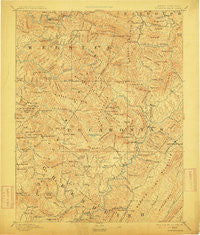
~ Huntersville WV topo map, 1:125000 scale, 30 X 30 Minute, Historical, 1894, updated 1912
Huntersville, West Virginia, USGS topographic map dated 1894.
Includes geographic coordinates (latitude and longitude). This topographic map is suitable for hiking, camping, and exploring, or framing it as a wall map.
Printed on-demand using high resolution imagery, on heavy weight and acid free paper, or alternatively on a variety of synthetic materials.
Topos available on paper, Waterproof, Poly, or Tyvek. Usually shipping rolled, unless combined with other folded maps in one order.
- Product Number: USGS-5638713
- Free digital map download (high-resolution, GeoPDF): Huntersville, West Virginia (file size: 10 MB)
- Map Size: please refer to the dimensions of the GeoPDF map above
- Weight (paper map): ca. 55 grams
- Map Type: POD USGS Topographic Map
- Map Series: HTMC
- Map Verison: Historical
- Cell ID: 395865
- Scan ID: 253978
- Imprint Year: 1912
- Survey Year: 1889
- Datum: Unstated
- Map Projection: Unstated
- Map published by United States Geological Survey
- Map Language: English
- Scanner Resolution: 600 dpi
- Map Cell Name: Huntersville
- Grid size: 30 X 30 Minute
- Date on map: 1894
- Map Scale: 1:125000
- Geographical region: West Virginia, United States
Neighboring Maps:
All neighboring USGS topo maps are available for sale online at a variety of scales.
Spatial coverage:
Topo map Huntersville, West Virginia, covers the geographical area associated the following places:
- Linwood - Modoc - Curtin - Brownsburg - Ralph - Trainer - Hillsboro - Woodrow - Locust - North Bend - Droop - Cherry Falls - Thorny Creek - Huntersville - Stillwell - Marlinton - Burr - Upper Mingo - Mill Point - Mace - Jerryville - Kennison - Raintown - Lobelia - Droop Mountain - Parcoal - Horrock - Knapp - Cordova - Denmar - Harter - Beard Heights - Burnsides - Renicks Valley - Violet - Slaty Fork - Esty - Whiteoak Grove - Edray - Mill Run (historical) - Trout - Bergoo - Seebert - Watoga - Dogway - Onoto - Dyer - Brush Camp Low Place - Skidmore Crossing - Webster Springs - Leonard - Mingo - Bolair - Friars Hill - Julia - Buckeye - Beard - Oscar - Spice - Walnut - Excelsior - Dorrtown - Warwick - Jacox - Campbelltown - West Union - Rorer - Clawson - Golden - Loveridge
- Map Area ID: AREA38.538-80.5-80
- Northwest corner Lat/Long code: USGSNW38.5-80.5
- Northeast corner Lat/Long code: USGSNE38.5-80
- Southwest corner Lat/Long code: USGSSW38-80.5
- Southeast corner Lat/Long code: USGSSE38-80
- Northern map edge Latitude: 38.5
- Southern map edge Latitude: 38
- Western map edge Longitude: -80.5
- Eastern map edge Longitude: -80


