
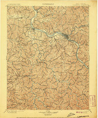
~ Charleston WV topo map, 1:125000 scale, 30 X 30 Minute, Historical, 1899, updated 1907
Charleston, West Virginia, USGS topographic map dated 1899.
Includes geographic coordinates (latitude and longitude). This topographic map is suitable for hiking, camping, and exploring, or framing it as a wall map.
Printed on-demand using high resolution imagery, on heavy weight and acid free paper, or alternatively on a variety of synthetic materials.
Topos available on paper, Waterproof, Poly, or Tyvek. Usually shipping rolled, unless combined with other folded maps in one order.
- Product Number: USGS-5638689
- Free digital map download (high-resolution, GeoPDF): Charleston, West Virginia (file size: 13 MB)
- Map Size: please refer to the dimensions of the GeoPDF map above
- Weight (paper map): ca. 55 grams
- Map Type: POD USGS Topographic Map
- Map Series: HTMC
- Map Verison: Historical
- Cell ID: 395872
- Scan ID: 253959
- Imprint Year: 1907
- Survey Year: 1897
- Datum: Unstated
- Map Projection: Unstated
- Map published by United States Geological Survey
- Map Language: English
- Scanner Resolution: 600 dpi
- Map Cell Name: Charleston
- Grid size: 30 X 30 Minute
- Date on map: 1899
- Map Scale: 1:125000
- Geographical region: West Virginia, United States
Neighboring Maps:
All neighboring USGS topo maps are available for sale online at a variety of scales.
Spatial coverage:
Topo map Charleston, West Virginia, covers the geographical area associated the following places:
- Jefferson - Morrisvale - Sun Valley - Woods and Irons South - Davis Creek - Poplar Point Estates - Oakwood Estates - Sterling (historical) - Ranch Lake Estates - Easly - Black Lick Estates - Snowden - Teays Valley - Poca - Hickory Hill - Maxine - Lexington Estates - East Side - Brush Creek - Milliken - Fork Junction - Prenter - Riverside Mobile Home Park - Oakwood - Hollyhurst - Roseville Addition - Englewood Estates - Green Valley - Mount Hope - Belvil Park - Low Gap - Bloomingrose - Black Betsey - Bulger - Colonial Gardens - Hidden Valley Estates - Tango - Joes Creek - Coopertown - Emmons - Teays Meadow - Tyler Heights - Rock Creek - Forest Hills - Rumble - Chesapeake - Woods and Irons East - Lory - Valley View Estates - South Ruffner - Kanawha Estates - Elk - Quinland - Sleepy Hollow Township - Keith - Fosterville - Valley Brook Mobile Home Park - The Ridge Estates - Loudon Heights - Cross Lanes - Scott Village - Cabot - Cameo - Teays - Sun Valley Estates - Adams - Parkway Terrace - Mink (historical) - Windsong Acres - Sod - Spring Hill - Fort Hill - Ferrell - Danville - Joplin - Indian (historical) - Tornado - Nitro - Belle - Fairway Gardens - Kenna Homes - Dollie - Ortin Heights - Williams Mountain - Olcott - Woodcliffe Chase - Nelson - Johns - Brushton - Creed - Mount Vernon Meadows - Sandy - Pocatalico - Calvert (historical) - Copenhaver (historical) - Peytona - Elk Forest - Teays Village - Silver Valley Estates - Sylvester
- Map Area ID: AREA38.538-82-81.5
- Northwest corner Lat/Long code: USGSNW38.5-82
- Northeast corner Lat/Long code: USGSNE38.5-81.5
- Southwest corner Lat/Long code: USGSSW38-82
- Southeast corner Lat/Long code: USGSSE38-81.5
- Northern map edge Latitude: 38.5
- Southern map edge Latitude: 38
- Western map edge Longitude: -82
- Eastern map edge Longitude: -81.5


