
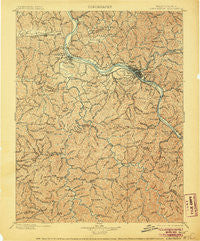
~ Charleston WV topo map, 1:125000 scale, 30 X 30 Minute, Historical, 1899, updated 1906
Charleston, West Virginia, USGS topographic map dated 1899.
Includes geographic coordinates (latitude and longitude). This topographic map is suitable for hiking, camping, and exploring, or framing it as a wall map.
Printed on-demand using high resolution imagery, on heavy weight and acid free paper, or alternatively on a variety of synthetic materials.
Topos available on paper, Waterproof, Poly, or Tyvek. Usually shipping rolled, unless combined with other folded maps in one order.
- Product Number: USGS-5638687
- Free digital map download (high-resolution, GeoPDF): Charleston, West Virginia (file size: 13 MB)
- Map Size: please refer to the dimensions of the GeoPDF map above
- Weight (paper map): ca. 55 grams
- Map Type: POD USGS Topographic Map
- Map Series: HTMC
- Map Verison: Historical
- Cell ID: 395872
- Scan ID: 253958
- Imprint Year: 1906
- Survey Year: 1897
- Datum: Unstated
- Map Projection: Unstated
- Map published by United States Geological Survey
- Map Language: English
- Scanner Resolution: 600 dpi
- Map Cell Name: Charleston
- Grid size: 30 X 30 Minute
- Date on map: 1899
- Map Scale: 1:125000
- Geographical region: West Virginia, United States
Neighboring Maps:
All neighboring USGS topo maps are available for sale online at a variety of scales.
Spatial coverage:
Topo map Charleston, West Virginia, covers the geographical area associated the following places:
- Snow Hill - McCorkle - Adams - Country Villas - Ferrell - Emmons - Peytona - Oakwood Estates - Sun Valley - Sproul - Prenter - Price Hill - Winifrede Junction - Spring Hill - Riverview - Blackhawk - Dodson Junction - Teays - Olcott - Hickory Hill - Summit - Sattes - Highlawn - Pocatalico - Windsong Acres - Fork Junction - Lanham - Priestley - Twin Rivers Mobile Home Park - North Charleston - Silver Valley Estates - Madison - Rock Lake Village - Washington Heights - Yawkey - Forest Hills - Black Betsey - Mount Vernon Meadows - Teays Village - Sweet Acres - Horse Creek Junction - Scary - Altman - Chesapeake - Etowah - Mink (historical) - Port Amherst - Lincoln Park - Aarons - Edgewood - Brush Creek - South Madison - Glass Addition - Wallace - Uneeda - Keith - Sylvester - Teays Farm - Morgans Landing - Tornado - Copenhaver (historical) - Dickinson - Sharlow - Roseville Addition - Nellis - Dollie - Cross Lanes - East (historical) - Johns - Lower Belle - Rand - Loudon Heights - Milltown - Barlow (historical) - Ridgeview - Andrew - Elk - Virginia Heights - Teays Valley - Racine - South Park - Van Camp - Autumn Wynds - Ivydale - Belle - Fosterville - Institute - Dartmont - Sandy - Kanawha City - Poca - Scott Depot - Riverlake - Calvert (historical) - Kenmar Trailer Park - Woods and Irons - Layville - Raymond City - Green Valley - Brounland
- Map Area ID: AREA38.538-82-81.5
- Northwest corner Lat/Long code: USGSNW38.5-82
- Northeast corner Lat/Long code: USGSNE38.5-81.5
- Southwest corner Lat/Long code: USGSSW38-82
- Southeast corner Lat/Long code: USGSSE38-81.5
- Northern map edge Latitude: 38.5
- Southern map edge Latitude: 38
- Western map edge Longitude: -82
- Eastern map edge Longitude: -81.5


