
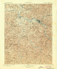
~ Charleston WV topo map, 1:125000 scale, 30 X 30 Minute, Historical, 1899, updated 1904
Charleston, West Virginia, USGS topographic map dated 1899.
Includes geographic coordinates (latitude and longitude). This topographic map is suitable for hiking, camping, and exploring, or framing it as a wall map.
Printed on-demand using high resolution imagery, on heavy weight and acid free paper, or alternatively on a variety of synthetic materials.
Topos available on paper, Waterproof, Poly, or Tyvek. Usually shipping rolled, unless combined with other folded maps in one order.
- Product Number: USGS-5638685
- Free digital map download (high-resolution, GeoPDF): Charleston, West Virginia (file size: 13 MB)
- Map Size: please refer to the dimensions of the GeoPDF map above
- Weight (paper map): ca. 55 grams
- Map Type: POD USGS Topographic Map
- Map Series: HTMC
- Map Verison: Historical
- Cell ID: 395872
- Scan ID: 253957
- Imprint Year: 1904
- Survey Year: 1897
- Datum: Unstated
- Map Projection: Unstated
- Map published by United States Geological Survey
- Map Language: English
- Scanner Resolution: 600 dpi
- Map Cell Name: Charleston
- Grid size: 30 X 30 Minute
- Date on map: 1899
- Map Scale: 1:125000
- Geographical region: West Virginia, United States
Neighboring Maps:
All neighboring USGS topo maps are available for sale online at a variety of scales.
Spatial coverage:
Topo map Charleston, West Virginia, covers the geographical area associated the following places:
- Julian - Milltown - Ballard (historical) - Poca - Calvert (historical) - Garretts Bend - Forks of Coal - Foch - Candlewyck Place - Knollwood - Meadowbrook - Rock Branch - Winsor Court - Alum Creek - Ridgeview - Cross Lanes - Kirbyton - Etowah - Sleepy Hollow Township - Roseville Addition - Griffithsville - Summit - Pocatalico - South Madison - Dollie - Dickinson - Wilson - Brush Creek - River Bend - Hollyhurst - Rocky Fork - Sandy - Valley View Estates - Grippe - Harless - Horse Creek Junction - Belle Acres - Strawberry Heights - Hernshaw - Layville - Teays - Morgans Landing - Washington Heights - Teays Valley Estates - Kenna Homes - Price Hill - Bulger - Teays Farm - Turtle Creek - Seth - Mink (historical) - Sproul - Cameo - Scary - Wallace - Easly - Hickory Hill - Hopkins - South Malden - Hidden Valley Estates - Rumble - Teays Valley Meadows - Creed - Green Valley - Springlea Estates - Institute - Belle - Maxine - Guthrie - Danville - Silver Valley Estates - Kanawha City - Lincoln (historical) - Englewood Estates - Saunders Addition - Alkol - East Side - South Charleston - Adams - Dodson Junction - Ferrell - Comfort - Quinland - Ivydale - Big Chimney - Prenter - Irene - Fuquay (historical) - Snow Hill - Kanawha Estates - Lanham - Riverview - Cheyenne Valley - Bloomingrose - Tyler Heights - Ranch Lake Estates - South Hills - Ruth - Marlaina Addition - Vandalia
- Map Area ID: AREA38.538-82-81.5
- Northwest corner Lat/Long code: USGSNW38.5-82
- Northeast corner Lat/Long code: USGSNE38.5-81.5
- Southwest corner Lat/Long code: USGSSW38-82
- Southeast corner Lat/Long code: USGSSE38-81.5
- Northern map edge Latitude: 38.5
- Southern map edge Latitude: 38
- Western map edge Longitude: -82
- Eastern map edge Longitude: -81.5


