
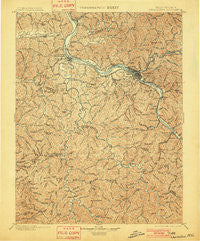
~ Charleston WV topo map, 1:125000 scale, 30 X 30 Minute, Historical, 1899, updated 1901
Charleston, West Virginia, USGS topographic map dated 1899.
Includes geographic coordinates (latitude and longitude). This topographic map is suitable for hiking, camping, and exploring, or framing it as a wall map.
Printed on-demand using high resolution imagery, on heavy weight and acid free paper, or alternatively on a variety of synthetic materials.
Topos available on paper, Waterproof, Poly, or Tyvek. Usually shipping rolled, unless combined with other folded maps in one order.
- Product Number: USGS-5638683
- Free digital map download (high-resolution, GeoPDF): Charleston, West Virginia (file size: 13 MB)
- Map Size: please refer to the dimensions of the GeoPDF map above
- Weight (paper map): ca. 55 grams
- Map Type: POD USGS Topographic Map
- Map Series: HTMC
- Map Verison: Historical
- Cell ID: 395872
- Scan ID: 253956
- Imprint Year: 1901
- Survey Year: 1897
- Datum: Unstated
- Map Projection: Unstated
- Map published by United States Geological Survey
- Map Language: English
- Scanner Resolution: 600 dpi
- Map Cell Name: Charleston
- Grid size: 30 X 30 Minute
- Date on map: 1899
- Map Scale: 1:125000
- Geographical region: West Virginia, United States
Neighboring Maps:
All neighboring USGS topo maps are available for sale online at a variety of scales.
Spatial coverage:
Topo map Charleston, West Virginia, covers the geographical area associated the following places:
- Raymond City - North Charleston - Riverview - Scary - Rock Lake Village - Guthrie - Yawkey - Woodcliffe Chase - Hernshaw - Easly - Orgas - Rutledge - Twomile - Kenna Homes - Sweet Acres - East Side - Estep - Rumble - Winifrede - Sun Valley - Hillsdale - Baker Park - Cabot - Forks of Coal - Jefferson - Hopkins Fork - Breece - Fosterville - Layville - Winifrede Junction - Legg - Tornado - Forest Hills - East Nitro - Colonial Gardens - Elk Hills - Chesapeake - Aarons - Sod - Sattes - South Ruffner - Beech Park Acres - Sumerco - Lone Oak Park - Mount Vernon Meadows - Dickinson - Teays Valley Estates - Belvil Park - Copenhaver (historical) - Irene - Snowden - Seth - Autumn Wynds - Ortin Heights - Lory - Edgewood - Loudendale - Etowah - South Charleston - Racine - Ruthdale - Weberwood - Quinland - Sharlow - Candlewyck Place - Creed - Oakwood Estates - River Bend - Elk Forest - Olcott - Snow Hill - Sandy - Teays Valley Meadows - Glass Addition - Joplin - Ferrell - Elk - Dungriff - Teays Village - Adams - Riverdale Acres - Tango - Indian (historical) - Milltown - Teays - Springdale Estates - Bradley - Marmet - Mound (historical) - West Side - Diamond - Teays Valley - Fairway Gardens - Knollwood - Rock Creek - South Hills - Nitro - Dodson Junction - Wilson - South Park
- Map Area ID: AREA38.538-82-81.5
- Northwest corner Lat/Long code: USGSNW38.5-82
- Northeast corner Lat/Long code: USGSNE38.5-81.5
- Southwest corner Lat/Long code: USGSSW38-82
- Southeast corner Lat/Long code: USGSSE38-81.5
- Northern map edge Latitude: 38.5
- Southern map edge Latitude: 38
- Western map edge Longitude: -82
- Eastern map edge Longitude: -81.5


