
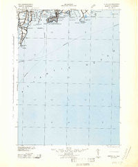
~ Newport RI topo map, 1:125000 scale, 30 X 30 Minute, Historical, 1942
Newport, Rhode Island, USGS topographic map dated 1942.
Includes geographic coordinates (latitude and longitude). This topographic map is suitable for hiking, camping, and exploring, or framing it as a wall map.
Printed on-demand using high resolution imagery, on heavy weight and acid free paper, or alternatively on a variety of synthetic materials.
Topos available on paper, Waterproof, Poly, or Tyvek. Usually shipping rolled, unless combined with other folded maps in one order.
- Product Number: USGS-5638355
- Free digital map download (high-resolution, GeoPDF): Newport, Rhode Island (file size: 12 MB)
- Map Size: please refer to the dimensions of the GeoPDF map above
- Weight (paper map): ca. 55 grams
- Map Type: POD USGS Topographic Map
- Map Series: HTMC
- Map Verison: Historical
- Cell ID: 66182
- Scan ID: 353536
- Edit Year: 1942
- Datum: NAD27
- Map Projection: Polyconic
- Map published by United States Army Corps of Engineers
- Map published by United States Army
- Map published by United States Department of War
- Map Language: English
- Scanner Resolution: 600 dpi
- Map Cell Name: New Port
- Grid size: 30 X 30 Minute
- Date on map: 1942
- Map Scale: 1:125000
- Geographical region: Rhode Island, United States
Neighboring Maps:
All neighboring USGS topo maps are available for sale online at a variety of scales.
Spatial coverage:
Topo map Newport, Rhode Island, covers the geographical area associated the following places:
- Narragansett Pier - Jamestown - Sachuest - Clarks Village - Peace Dale - Rodman Crossing (historical) - South Ferry - Bahia Corner - Purgatory - Tower Hill (historical) - Sakonnet - Seaweed Beach - Mooresfield - Point Judith - Brenton Village - Bridgetown - Bonnet Shores - Narragansett - Indian Lake Shores - Scarborough Hills - Narragansett Beach - Newport - Pettaquamscutt Lake Shores - Whale Rock Light (historical)
- Map Area ID: AREA41.541-71.5-71
- Northwest corner Lat/Long code: USGSNW41.5-71.5
- Northeast corner Lat/Long code: USGSNE41.5-71
- Southwest corner Lat/Long code: USGSSW41-71.5
- Southeast corner Lat/Long code: USGSSE41-71
- Northern map edge Latitude: 41.5
- Southern map edge Latitude: 41
- Western map edge Longitude: -71.5
- Eastern map edge Longitude: -71


