
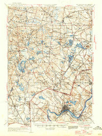
~ Hampstead NH topo map, 1:62500 scale, 15 X 15 Minute, Historical, 1935, updated 1947
Hampstead, New Hampshire, USGS topographic map dated 1935.
Includes geographic coordinates (latitude and longitude). This topographic map is suitable for hiking, camping, and exploring, or framing it as a wall map.
Printed on-demand using high resolution imagery, on heavy weight and acid free paper, or alternatively on a variety of synthetic materials.
Topos available on paper, Waterproof, Poly, or Tyvek. Usually shipping rolled, unless combined with other folded maps in one order.
- Product Number: USGS-5638177
- Free digital map download (high-resolution, GeoPDF): Hampstead, New Hampshire (file size: 10 MB)
- Map Size: please refer to the dimensions of the GeoPDF map above
- Weight (paper map): ca. 55 grams
- Map Type: POD USGS Topographic Map
- Map Series: HTMC
- Map Verison: Historical
- Cell ID: 55165
- Scan ID: 330069
- Imprint Year: 1947
- Survey Year: 1931
- Datum: NAD
- Map Projection: Polyconic
- Map published by United States Geological Survey
- Keywords: Overedge
- Map Language: English
- Scanner Resolution: 600 dpi
- Map Cell Name: Haverhill
- Grid size: 15 X 15 Minute
- Date on map: 1935
- Map Scale: 1:62500
- Geographical region: New Hampshire, United States
Neighboring Maps:
All neighboring USGS topo maps are available for sale online at a variety of scales.
Spatial coverage:
Topo map Hampstead, New Hampshire, covers the geographical area associated the following places:
- West Hampstead - Crane Crossing - Rowes Corner - Newton Junction - South Danville - Groveland - Maple Park - Hubbard - Tozier Corner - Highlandville - Millville - Powwow River - East Kingston - Sargent Corners - Hampstead - Highlands - North Salem - Noyes Terrace - Atkinson - Canobie Lake - Westville - North Danville - Bradford - Wilson Corners - Kingston - Danville - Collettes Grove - Graceland Park - Foster Corners - Cluffs Crossing - East Hampstead - Grosvenor Corner - Pages Corner - Pine Grove Park - Cowbell Corners - West Parish - Brentwood - Ayers Village - Haverhill - Chases Grove - Marshall Corner - West Kingston - Newton - Fremont Station - Riverside - Conleys Grove - Arlington Park - Howards Grove - Salem - Rocks Village - Fremont - South Kingston - Baglett Grove - Salem Depot - Ward Hill - Atkinson Heights - Merrimac - Plaistow - Rosemont - Sandown
- Map Area ID: AREA4342.75-71.25-71
- Northwest corner Lat/Long code: USGSNW43-71.25
- Northeast corner Lat/Long code: USGSNE43-71
- Southwest corner Lat/Long code: USGSSW42.75-71.25
- Southeast corner Lat/Long code: USGSSE42.75-71
- Northern map edge Latitude: 43
- Southern map edge Latitude: 42.75
- Western map edge Longitude: -71.25
- Eastern map edge Longitude: -71


