
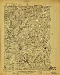
~ Pittsfield ME topo map, 1:48000 scale, 15 X 15 Minute, Historical, 1930
Pittsfield, Maine, USGS topographic map dated 1930.
Includes geographic coordinates (latitude and longitude). This topographic map is suitable for hiking, camping, and exploring, or framing it as a wall map.
Printed on-demand using high resolution imagery, on heavy weight and acid free paper, or alternatively on a variety of synthetic materials.
Topos available on paper, Waterproof, Poly, or Tyvek. Usually shipping rolled, unless combined with other folded maps in one order.
- Product Number: USGS-5638029
- Free digital map download (high-resolution, GeoPDF): Pittsfield, Maine (file size: 9 MB)
- Map Size: please refer to the dimensions of the GeoPDF map above
- Weight (paper map): ca. 55 grams
- Map Type: POD USGS Topographic Map
- Map Series: HTMC
- Map Verison: Historical
- Cell ID: 61041
- Scan ID: 807627
- Survey Year: 1930
- Datum: NAD
- Map Projection: Polyconic
- Advance: Yes
- Map published by United States Geological Survey
- Keywords: Overedge; Nonstandard Press Run
- Map Language: English
- Scanner Resolution: 508 dpi
- Map Cell Name: Pittsfield
- Grid size: 15 X 15 Minute
- Date on map: 1930
- Map Scale: 1:48000
- Geographical region: Maine, United States
Neighboring Maps:
All neighboring USGS topo maps are available for sale online at a variety of scales.
Spatial coverage:
Topo map Pittsfield, Maine, covers the geographical area associated the following places:
- West Palmyra - Lincoln Mills - Waverley - Marsh Corner - Newport - Palmyra - Tilton Corner - Pleasant Vale Corner - Dogtown - Johnson Corner - Plummer Corner - Todds Corner - Thompson Corner - Detroit - Bog Corner - Mosher Corner - Miles Corner - Ellis Corner - Cyrs - Nutter Corner - Dixie Corner - Hartland - Pittsfield - Hurd Corner - Thompson - Houston Corner - Wildwood - Moody - Knox Hill Corner - Emerson Corner - Corinna - Manson Corner - Goodwin Corner - Sanborn Corner - Hasty Corner - Saint Albans - Stronghold - Miller Corner - Lyford Corner - Dow Corner - Ripley - Katen Corner - Phillips Corner - Burton Corner - Rowe Corner - Weeks Corner
- Map Area ID: AREA4544.75-69.5-69.25
- Northwest corner Lat/Long code: USGSNW45-69.5
- Northeast corner Lat/Long code: USGSNE45-69.25
- Southwest corner Lat/Long code: USGSSW44.75-69.5
- Southeast corner Lat/Long code: USGSSE44.75-69.25
- Northern map edge Latitude: 45
- Southern map edge Latitude: 44.75
- Western map edge Longitude: -69.5
- Eastern map edge Longitude: -69.25


