
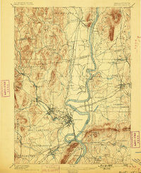
~ Northampton MA topo map, 1:62500 scale, 15 X 15 Minute, Historical, 1895, updated 1899
Northampton, Massachusetts, USGS topographic map dated 1895.
Includes geographic coordinates (latitude and longitude). This topographic map is suitable for hiking, camping, and exploring, or framing it as a wall map.
Printed on-demand using high resolution imagery, on heavy weight and acid free paper, or alternatively on a variety of synthetic materials.
Topos available on paper, Waterproof, Poly, or Tyvek. Usually shipping rolled, unless combined with other folded maps in one order.
- Product Number: USGS-5635737
- Free digital map download (high-resolution, GeoPDF): Northampton, Massachusetts (file size: 10 MB)
- Map Size: please refer to the dimensions of the GeoPDF map above
- Weight (paper map): ca. 55 grams
- Map Type: POD USGS Topographic Map
- Map Series: HTMC
- Map Verison: Historical
- Cell ID: 60335
- Scan ID: 352902
- Imprint Year: 1899
- Survey Year: 1885
- Datum: Unstated
- Map Projection: Unstated
- Map published by United States Geological Survey
- Map Language: English
- Scanner Resolution: 600 dpi
- Map Cell Name: Northampton
- Grid size: 15 X 15 Minute
- Date on map: 1895
- Map Scale: 1:62500
- Geographical region: Massachusetts, United States
Neighboring Maps:
All neighboring USGS topo maps are available for sale online at a variety of scales.
Spatial coverage:
Topo map Northampton, Massachusetts, covers the geographical area associated the following places:
- Leverett Station - South Deerfield - Cushman - Searsville - Westbrook - East Whately - Florence - Laurel Park - Hadley - Sunderland - North Hadley - Amherst Center - North Hatfield - Northampton - South Hadley - Easthampton - Whately - Thermopylae - West Whately - Williamsburg - Bay State - Russellville - Pine Grove - Leverett - Mill Valley - Mount Tom - Bradstreet - Amherst - Loudville - Aldrich Mills - Plainville - West Farms - South Amherst - Smiths Ferry - Factory Hollow - Roaring Brook Camp - Hockanum - East Hadley - North Farms - Hatfield - North Amherst - Williamsburg Station - West Hatfield - Haydenville - Granby - Moody Corner - Leeds
- Map Area ID: AREA42.542.25-72.75-72.5
- Northwest corner Lat/Long code: USGSNW42.5-72.75
- Northeast corner Lat/Long code: USGSNE42.5-72.5
- Southwest corner Lat/Long code: USGSSW42.25-72.75
- Southeast corner Lat/Long code: USGSSE42.25-72.5
- Northern map edge Latitude: 42.5
- Southern map edge Latitude: 42.25
- Western map edge Longitude: -72.75
- Eastern map edge Longitude: -72.5


